 Today's latest GISuser Geospatial & GIS news updates
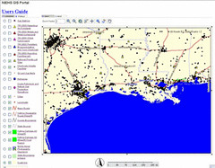
Originally uploaded by GISuser.com.Image: The NIEHS GIS portal assembles data about contaminents, oil & gas refineries, and other relevant data themes - see today's GISuser spotlight feature or jump directly to http://www-apps.niehs.nih.gov/katrina/
Latest GIS / Geospatial news updates:
- Analytical Surveys Engages Wind Lake Solutions
- Tom Clay Named CEO of Z Corporation, Maker of World's Fastest Color 3D Printers
- Tri-County CML Emergency Communications System Deployed on Florida's Gulf Coast
- EWEB Selects ArcFM Viewer for Mobile Solution
- LiDAR Services International, W.I.R.E. Services / Manitoba Hydro Sign 5 year LiDAR Services Contract
- Discover the latest developments in GIS solutions; ESRI (UK) Tech Update events series
- LotInfo Offers Software That Uses a Lot Level Map to Access Property Information in New York City
- Oracle Announces General Availability of Oracle(R) TimesTen In-Memory Database 6.0
- RMS Releases Third Generation of its Japan Earthquake Catastrophe Model
- Ecology and Environment, Inc. Wins Top Award in World Challenge
- STAR INFORMATIC software to manage Moroccan harbours
- Campbell County, Wyoming Selects Geographic Technologies Group (GTG) for GIS Data Development
GIS & Environmental Hazard Assessment from Hurricane Katrina - To visualize relationships, model the movement of contaminants, and identify sources of human exposure, the NIEHS is developing an
interactive Geographic Information System (GIS). This GIS assembles maps for Texas, Louisiana and Mississippi based on geographic, demographic, hydrographic, infrastructure and industrial/agricultural data from publicly accessible sources. See http://www.gisuser.com/content/view/7089/28/