From the European Space Agency... A prototype service utilising satellites for mapping forests to aid compliance with the Kyoto Protocol has been endorsed by end users from European countries – one environmental ministry representative called the baseline carbon stock information provided a "goldmine". See more at http://www.esa.int/esaCP/SEMV5V638FE_index_0.html

November 12, 2005
November 11, 2005
Open Source Programming Certificate Series
From the Oreilly Learning Lab: Open Source Programming Certificate Series Special - With beginning to intermediate courses in Perl, Java, PHP, MySQL, and the Linux/Unix file system, our Open Source Programming Certificate Series is designed to give you a breadth of real-world experience. Upon completion of the series, you'll receive a Certificate of Professional Development from the University of Illinois Office of Continuing Education, a plus for any resume. Enroll in all five courses and receive a $300 instant rebate. Offer expires November 30th. Details at http://oreilly.useractive.com/courses/opensource.php3?CMP=NLC-BP1997714547
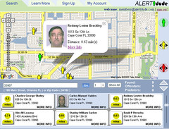
Alertdude Google Mashup maps Florida sexual offenders
Alertdude Google Mashup maps Florida sexual offenders
Originally uploaded by GISuser.com.
We've seen mashups recently that are mapping and tracking sexual
predators, however, alertdude is taking things a bit further. The site
only maps Florida predators at the moment, however, the user interface
is very slick and this application adds some e-commerce into the mix by
enabling users to subscribe to alerts. The mapping is not your typical,
vanilla google mash-up as it has loads of bells and whistles. The app is
relatively fast and uses some nifty technology. The author tells us, the
flash movie sends the xml to the browser as a string, which is then
loaded and parsed in javascript. The xmldom then parses the file to
create the markers and the description used in the info window. Users
can search by address or a simple zip code. Results show up as
attractive icons depicting either predators or offenders. Clicking on
the icon provides additional information (to registered users) and
displays a photo of the offender along with a description and criminal
history. Try it out at http://www.alertdude.com - I can't wait to see
this application expanded! Users can join to get instant alerts,
detailed offender info and action reports for $1.99 monthly.
SeaZone launches marine geographical data products
SeaZone has launched its new range of marine geographical data products at the AGI Conference, Chelsea Village, London on 8-10 November 2005.
In particular, SeaZone will celebrate the introduction of its new dataset, SeaZone Hydrospatial. The dataset represents an important milestone for the UK, as for the first time it comprises information unavailable from nautical charting. The dataset is fully GIS-compatible, is easy to use and implement without the need for plug-ins, and is inter-operable with Ordnance Survey data products such as OS MasterMap. You can see more at http://www.seazone.com
Google Reader - New on Google Labs
Google Reader can help you keep up with the firehose of info coming your way from blogs and websites. New on Google Labs, it automatically gets the latest news and updates from sites you pick. You can sort your reading list by relevance, and you can share the good bits with friends via an easy email or blog tool within Reader. You can also star or label things you want to save for yourself, too.
http://reader.google.comGIS & GISCorps go prime-time on CNN
Geospatial technologies are gaining more recognition every day. the latest, a report on CNN that looks at how geocoding was a central part in the Hurricane Katrina Search efforts. Now us involved in "geo" are well aware of the capabilities that exist, however, now the mainstream user and reader of CNN is becoming aware of just how signifcant GIS and Geospatial technologies really are. From the article... "They [Coast Guard] would get phone calls, or the Coast Guard would come in with addresses in their hands and say, 'I need a latitude and longitude for this address.' So the GIS professionals would do a geocoding, give it to the Coast Guard who got on helicopters and saved lives," said Shoreh Elhami, director of GISCorps. See teh article here - http://www.cnn.com/2005/TECH/11/10/gis.technology/
November 10, 2005
International LIDAR Mapping Forum (ILMF) 2006 Denver, Colorado on February 13 and 14, 2006
The most important event of the year for the LIDAR mapping industry will take place in
Ordnance Survey MapZone
A series of role-play missions to help youngsters understand and enjoy working with digital map data is revealed on a newly created section in
Welsh of MapZone, a free, interactive website by Britain's national mapping agency, Ordnance Survey. GIS Zone is now available in the Welsh language and brings geographical information systems (GIS) to life for 11-16-year-olds. See http://www.ordnancesurvey.co.uk/mapzone
Welsh of MapZone, a free, interactive website by Britain's national mapping agency, Ordnance Survey. GIS Zone is now available in the Welsh language and brings geographical information systems (GIS) to life for 11-16-year-olds. See http://www.ordnancesurvey.co.uk/mapzone
November 09, 2005
AUGI launches BLAUGI.. CAD blog site
Kudos and congrats to the folks at AUGI who have launched BLAUGI, the official weblog for the user group. If you need anything to do with CAD, in particular AUTOCAD then you'll enjoy this resource. No doubt this will be a useful information line for news coming out of AU which takes place later this month. See http://augi.typepad.com/
Rand McNally has joined the likes of Google and Yahoo!
Rand McNally has joined the likes of Google and Yahoo! by offering developers a chance to Incorporate maps & directions in Web Sites. The offering, billed as MapEngine is available as an API or web service. More info on this can be found at http://www.randmcnally.com/mapengine
November 08, 2005
Handango Tablet PC shop goes online
This announcement will be of interest to mobile professionals... Handango, the leading provider of mobile content, announced that it has entered the rapidly-growing market for downloadable Tablet PC software with the launch of a Tablet PC catalog. Customers can download applications on Handango's Web site at http://www.handango.com/ and on the Microsoft Windows XP Tablet PC Software store at http://microsoft.handango.com/tablet .
November 07, 2005
USDA UAV mapping proposal
The USDA Forest Service and NASA Ames Research Center are seeking small unmanned aerial vehicles to support an upcoming wildfire mapping demonstration. The early 2006 event is a follow-on to UAV/wildfire monitoring research conducted this past summer. All needed materials and contact information for interested parties will be posted on the demonstration website: http://nirops.fs.fed.us/UASDemo
Govtech applauds Kentucky GIS mapsite
Commonwealth Office of Technology's Division of Geographic Information created a custom Internet mapping site to showcase Kentucky's outstanding state parks system. The site went online in early 2005 and was published to the growing KYGEONET GIS mapping system. A review of usage statistics through mid-2005 indicated that few people had found or were using the site. After a few simple changes, however, the use of the new maps has increased dramatically and the Kentucky State Parks GIS mapping site is breaking records - See http://www.govtech.net/magazine/channel_story.php/97163
GISuser mail - mologogo, podcasts
I was just sifting through the "gisuser" mailbag and came across a few interesting items I'd like to share. Users can share their location in real-time with others..see mologogo http://www.mologogo.com/ a free service that will track a friends GPS enabled cell phone from another phone or on the web... pretty nifty! Interested in hearing a podcast with Jack Dangermond and Tim Oreilly... see A Conversation with Tim O'Reilly at itconversations - http://www.itconversations.com/shows/detail651.html
Google Local Goes Mobile Today
Google today has launched "Local for Mobile", a downloadable application for viewing Google Local and Google Maps on your mobile phone. It combines the directions and business directory services of Google Local + maps with integrated search results from Google Search. You can even view the satellite views from Google Maps through this application. FYI, its not supported on devices provided by Verizon, Nextel, Alltel, U.S. Check out http://www.google.com/gml/
Subscribe to:
Posts (Atom)