
March 25, 2006
Mapping Avian flu using Google Earth - developed with ArcGIS and Arc2Earth
Declan Butler has updated his already popular avian flu mapping thanks to the release of arc2Earth. Declan is now producing a KML for use in google earth which is updated automatically each week. The maps and data provide information about human and poultry outbreaks and information about each individual occurence is provided... nice stuff! the new maps are avaiable from http://declanbutler.info/Flumaps1/avianflu.html and you can get the KML at http://www.declanbutler.info/Flumaps1/top_parent_network_link.kml - a reminder... I'm phasing out this blog as I've migrated to a new home at http://my.opera.com/gisuser/
March 24, 2006
GISuser Chat - Google Mashup Chat Room enabled by Mapable... this is way cool!
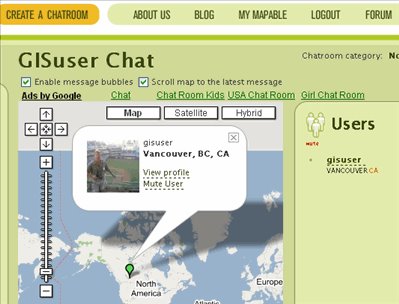
This is cool... an online social application enabling you to create your own chat room that's integrated with Google MAps. Users create a profiule and when logged in a bubble displays who's online and where they are. The application took me about one minute to develop my own chat room - GISuser Chat - http://www.mapable.com/gisuser?title=GISuser%20Chat - you may also be able to access it from http://www.mapable.com/gisuser - this is totally cool!! You may have to sign up as a user but that's very painless... kudos to Mapable for a very slick app! To try it out jump to my chat room, login and send me a message
Anything Geospatial... should I do it?

I'm searching for feedback on my "new and improved" Blog titled Anything Geospatial - http://my.opera.com/gisuser/ -- Should I stay or should I go? I've been messing with the my.opera blog functionality for a bit but I can't decide whether to flip the switch or not. What's your take? Any comments? The blogger blog (this one here) has served it's purpose and there's likely many links in and people sucking in the RSS feed, so I'm obviously worried about ticking off those people by moving. If I move will it affect you or do you even care?? Unless I see any major issues I'm thinking that this week-end or Monday I'll pull the plug on blogging here and Use the my.opera GISuser blog that I've developed at http://my.opera.com/gisuser/ ... I even have a name... Anything Geospatial
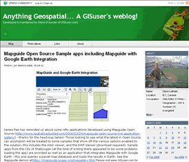
Mapguide Open Source Sample apps including Mapguide with Google Earth Integration

James Fee has reminded us about some nifty applications developed using Mapguide Open Source (http://www.spatiallyadjusted.com/2006/03/24/mapguide-open-source-live-application-gallery/) - thanks for the head-sup James! Those looking to see what the latest in Open Source can accomplish will be treated to some samples that show off the various options enabled by the solution, this includes the AJAX viewer, and the DWF Viewer (download required). Sample apps from the City of Sheboygan (at the time of writing there appeared to be some problems loading the app) are provided as well as an application that integrates Mapguide with Google Earth - this one queries a parcel map database and loads the results in Earth. See the Mapguide demos at https://mapguide.osgeo.org/livegallery.html
Mozilla Thunderbird and now the Lightning Project Calendar - any users?
Anyone out there using Mozilla thunderbird as an email client? (see http://www.mozilla.com/thunderbird/) . I think I may install this on my laptop and have some fun, especially since there's word of a new redesign of the calendar component that looks pretty slick. The redesign is billed as The Lightning Project. More on this at http://www.mozilla.org/projects/calendar/lightning.html
Dig VS Dot - digg or slashdot... have em both!
I was skimming Tim O'reilly's blog aka. the O'reilly Radar (http://radar.oreilly.com/) and noticed a very small mention to this interesting new app. I guess, you could call it a mashup that cross-posts the most recently cross-posted items from Digg and slashdot. Cross-posting is all the wave as everyone is in search of traffic and more traffic... ya I try this as well, sometimes blogging here, posting a mention of the blog in a discussion forum, re-blogging it in my Opera weblog, then digging it, yadayada.. why not.. everyone else is doing it! Sometimes the cross-posting trail does get a bit wild though... I recall this week catching wind of something of interest at allaboutsymbian. They had given kudos to a s60.com blogger for a nice job. Then, another blogger (Darla Mack) blogs a kudos to AAS for picking up on and mentioning a blog post at S60.. my lord, when does this end. Ok, I'm digressing... see Dig vs Dot at http://diggvsdot.com/
Symbian OS Freeware... Apps galore, growing strong
Burried within this popular downloads repository is a section title - Symbian OS Freeware. With some 75+ Apps. to date this collection of tools is rather impressive. The following piece shares with you the TOP 5 Symbian freeware apps from the directory and points you to some other fine resources available to symbian os smartphone users.
read more | digg story
read more | digg story
March 23, 2006
Mapquest Open API Developer Challenge extended to May 1 and now open to Canadian developers too!
Good news from Mapquest about their latest challenge to developers... the MapQuest OpenAPI Developers Challenge eligibility has been extended to Canada (excluding Quebec). In addition, the challenge’s deadline has been extended to May 1. The OpenAPI Developers Challenge (the "Contest") challenges registered members of the MapQuest OpenAPI community to create an original, non-commercial application using MapQuest OpenAPI which leverages the map interface to display data from at least one other source and incorporates the routing capabilities.More information and the latest rules at: http://www.mapquest.com/features/main.adp?page=developer_tools_oapi_devchallenge - are you developing with the MApquest API? Please share details of your experience with us - contact Glenn with your story!
A Mapserver and Mapguide Open Source Support solution
Did you know that you can get a 2 hour support package from DM Solutions enabling you to get up and running with Mapserver? Think of this as 2 hours of getting your hand held while you install this popular webmapping solution on your server. The 2 hour support package is offered at a reasonable cost and more details can be found at http://shop.dmsolutions.ca/mapserver_intro.html - DM Solutions Group is a leader in open source web mapping solutions and recently spun off a new company devoted to open source technology. Individuals looking for help getting up and running with Mapserver or Mapguide Open Source will appreciate their services. Related weblinks: http://www.dmsolutions.ca & https://mapguide.osgeo.org/gettingstarted.html
Autodesk 2007 lineup a go - enter Autodesk Map 3D, Civil 3D, and Raster Design 2007
Autodesk Today made it official and has delivered a comprehensive product portfolio spanning multiple Industries. Most noteworthy, AutoCAD 2007 and AutoCAD LT 2007 will be available in English, German and Japanese on March 23, 2006. Additional languages are planned to be released in the future. The pitch... New 3D Modeling, Collaboration, Visualization and Productivity Enhancements Help Customers to Realize their Ideas to Compete and Win. New infrastructure products hitting the shelf include:Autodesk Map 3D – the leading platform for creating and editing spatial data; Autodesk Civil 3D – maintains intelligent object relationships using an industry-proven dynamic engineering model; Autodesk Raster Design 2007 – edits or vectorizes scanned drawings without performing expensive redrafting. See more at http://www.gisuser.com/content/view/8489/ or jump to www.autodesk.com/infrastructure where a free 30 day trial is now available. Not a power CAD user? Autodesk also launched AutoCAD LT 2007 software today!
March 22, 2006
Open Access to USGS DEM data... Myth Or Reality?
I've had this article on the back burner for awhile but finally dusted it off and finished it up. For some time I've been wanting to bring up a discussion about the USGS' data distribution policy concerning the SDTS DEMs. Most people aren't losing sleep over this any longer as there's simply so many alternative resources available these days... it is, however, still an issue for some and the topic is frequently brought on on discussion lists and newsgroups. From the article... Say what you want about the SDTS format, however, given that USGS DEM data are distributed (natively) using the cumbersome SDTS data format there's not much you can do about that. But what about access to native USGS SDTS DEM data? You actually do have a say (somewhat) about it and many GIS professionals are still left wondering why these data are only available from a select few commercial data providers (portals)? Read on as we explore this topic a little deeper. http://www.gisuser.com/content/view/7797/28/
B&Bs now incorporating Google Maps, Google earth into web applications
The "news" headline found on a newswire service read "Pillows and Pancakes, a B&B guide, has released a layer for Google Earth." - at first glance you might think big deal, however, when you consider that the online travel/tourism industry is HUGE, to say the least, the news is actually pretty cool. Now, to us GIS-savvy users who come to expect maps and imagery within our apps this isn't rocket science, however, what this does do is confirm that there are indeed opportunities a plenty for application developers looking for work spatially-enabling web services.
Mashups providing locations of pubs, coffee shops, and even urinals are already on the scene, however, monetizing those apps may be problematic. Integrating maps with commercial reservation systems and the countless real estate sites out there may turn out to be the pot of gold at the end of the rainbow for mashers and web developers. Hopefully well start seeing some nifty Mapguide open source web apps (https://mapguide.osgeo.org/) in the near future as well as some products coming out of the ESRI camp once ArcGIS Explorer (https://mapguide.osgeo.org/) and their next generation of APIs are released to their developers... stay tuned. To see the B&B application mentioned above jump to http://www.pillowsandpancakes.com/ge.htm
ZoneTag grabs your cell tower geographic coordinates and flickr tags your photos for your moblog
Some of you avid readers of this blog will know that I'm interested in symbian smartphones and frequently share information about tools and applications of interest to mobile bloggers. Today I picked up on a cool app called zoneTag which is used to facilitate moblogging from Symbian series 60 devices (like the spanky Nokia N70) to your flickr moblog. Some of you US-based readers will be fortunate enough to try this application, however, when I went to actually use it I was once again disappointed to find out that it was only supported in the US and even worse, only then supported by a couple of mobile service plans and only by several Nokia devices (actually my device was on the list!) ... gee - there's a surprise! This is a really common problem in the mobile space as inter carrier operability and application development across the board is pretty much non-existent. Yahoo! even has some cool mobile tools but once again is limited in supported platforms and carriers. I guess until then I'll keep looking and hoping for more apps supported north of 49 degrees latitude and enabled by my Rogers plan. For details about Zonetag (the application tags your photos with the geographic coordinates of your nearest cell tower) see http://www.symbianone.com/content/view/3018/108/. There's also a pointer here to a cool moblog app called Shozu which is designed to save you data charges when uploaded photos from your phone... nice!
Google Earth Flying Cars.. the perfect traffic generator!
The amazing power of Google earth to entice traffic... I always get a chuck when non-news is picked up on by the mainstream media and mass hysteria persists for several weeks afterwards. For example, recall the mysterious flying car in Google earth a few weeks back... unless you were vacationing for the summer in Antarctica you couldn't have missed this one. Well, here we go again! Enter the "Flyin Globe" this time to get things rolling. Apparently they are convinced that another car is floating mysteriously. They proceed to post an image along with a KMZ file and related link to Google Maps. then the Sydney Morning Herald "reports" on the "news" and now all hell breaks lose. Online publication TMCnet has now picked it up and I assure you that others will follow suit. The allure here is the overwhelming temptation to have such buzzwords as "Google Earth" in your news headlines and meta tags in order to garner more web traffic, banner ad impressions, etc... If you really want to see this "news" for yourself you can jump here - http://www.flyinglobe.com/2006/03/15/another-flying-car-in-australia/ or simply trek to the following lat/long 32 06 42.54 s 115 45 53.17 e and see for yourself!
Expanded Options available for licensing Arc2Earth
Arc2Earth is now available with volume pricing discounts and an EDU package (40% discount) is also available as is a site license option... you should contact them directly for specifications and details - www.arc2earth.com This likely would have come ideally with the official launch, however, the developers were no doubt focused on getting the application out the door prior to the Dev Summit so you can't really blame them! For users searching out a community, Arc2Earth.com also has an online discussion forum where users can interact and look for help - see http://www.arc2earth.net/cs/
a Wireless home security solution
Most people forget about backing up, securing their networks, yadayada... for my home network I'm using the McAfee suite... overall it's quite suitable although there are a few quirky things that happen occasionally (i.e.. anti virus protection disabling itself...) Something you may wish to look at if you have a wireless network (home or office) is the new McAfee home network security bundle. It sells for about $50 but a recent offer has it available for about $10 (with mail in rebate) - a decent price for some added protection. See http://www.mcafee.com/wifi - do you have any tips of suggestions for some added wireless networking security??
March 20, 2006
MIX 2006 hosted by Microsoft sees much hoopla surrounding "ATLAS"
With all the recent hype around March madness recently you may have forgotten that MIX 06 is taking place right now in Vegas. Word on the street has it that ATLAS was the big buzz today at the 72 hour event - "Atlas" is a free framework for building a new generation of richer, more interactive, highly personalized standards based Web applications. “Atlas” makes AJAX-style development easier and more accessible to a broader range of developers, while enabling developers to enrich existing ASP.NET 2.0 applications. The new go-live license gives developers the opportunity to take their “Atlas” applications into production. For more about this I urge you to consult some of the following resources:
USGS announces 2007 earthquake research grants
The U.S. Geological Survey (USGS) announced today that it will award up to $5.5 million in National Earthquake Hazards Reduction Program (NEHRP) grants for earthquake research in 2007. Researchers interested can review the grant announcement and apply online at
www.grants.gov. Applications are due May 2, 2006.March 19, 2006
10% discount offer to attend O'Reilly Where 2.0 event
The O’Reilly Where 2.0 conference brings together the people, projects, and issues leading the charge into the location-based technology frontier. Location-aware technologies combined with mapping and other data are poised to create a whole new class of web apps and services. Where 2.0 will explore what's viable now, and what's lurking just below the radar. Meet the people behind the mash-ups and the platforms, and the people looking ahead to the future of geospatial. Where 2.0 will be held June 13-14, 2006 at the Fairmont Hotel San Jose, California. Early Registration ends April 24. LBS Zone readers can save 10% using code whr06lbsz. For more information visit http://conferences.oreilly.com/where
Subscribe to:
Posts (Atom)