
August 26, 2006
Brad Pasiley and Local Live Map tour
I've been a Brad Paisley fan for some time and now I'm more of a fan seeing that he's using Local Live to take fans on a tour of Memphis, TN. Check out this resource where Paisley shares some of his favorite destinations using the Local Live Map UI... nice touch
off topic and kudos on little league series
I just watched the little league world series US championship and how cool was it seeing such amazing sportsmanship from these kids. Kudos to the crew from Georgia for making it to the finals and even more congrats to them for being such gracious winners - they were taking a victory lap around the field but first they went and grabbed the Oregon team out of the duggout to join them -- a class move! I've always felt that it's pretty easy (and fun) to win, however, the true test is how well you bounce back after a loss...
Mashup developer challenge - a reminder
The BT Developer's Challenge is encouraging developers to create a mashup using some of the tools available via programmableweb. To the winner goes fame, fortune, and $2500... good luck, you have until Oct 6. see http://www.webdiscoveryhub.com/ and also http://www.programmableweb.com/
need a hotspot, try the Windows Live hotspot locator
Another handy tool for those of you in search of Internet Wi-Fi connectivity. This service (Beta) from Microsoft enables users to search a Global database of hotspots. Search by City, County for free or paid hotpots withing a specified distance. Try it out at http://hotspot.live.com/web/SearchView.aspx . Results are dipsplayed initially in tabular format along with free/paid attribute tag. Then you can click on a hotspot of your choice for additional info (ie service porovider) and get a map. Then email details to yourself or a friend... nice!
August 25, 2006
How do I do that in ArcGIS/Manifold - remember this one?
Some lively discussion about Manifold.net was spawned recently over at Spatially Adjusted (nice job throwing the bait out there and getting this going James!) The discussion made me think about a paper that was published a couple of years ago comparing how to accomplish tasks using Manifold.net (5) as compared to the same task done using ArcGIS. Would it be amazing to see such a publication that compares several applications??? Obviously a HUGE task but maybe there's a few keeners out there that have a few hundred hours to killl.. if so you'd have a best-seller on your hands! Here's some details about the publication I reference... "How do I do that in ArcGIS/Manifold" - Edited by Arthur Lembo Jr. Cornell university, the document steps through 50 "classic" GIS tasks and compares the process in Manifold side-by-side with the same process in ArcGIS... this document is a must read for anyone shopping for a low-cost GIS solution - this comes from a Spotlight feature at GU - see http://www.gisuser.com/content/view/3006/ - oh, and those of you who haven't already done so, the saga continues still over at Spatially Adjusted in this very heated discussion thread... ouch!!
August 24, 2006
Google Earth fly-over imagery available for relocation of Ramses II
Tracking Ramses using GE.. Archaeology enthusiasts, Egyptian history buffs, or simply anyone interested in great feats of engineering can witness Ramses' 24-hour journey from Cairo in Google Earth with the click of a mouse. This historic 16-mile relocation has been documented as a KML (Keyhole Markup Language) file which will overlay this route in Google Earth or Google Maps on the Google Blog at: http://googleblog.blogspot.com/2006/08/how-to-move-ramses-ii.html - Some background info... For over 50 years, exhaust
fumes from trains, cars and buses, as well as subway vibrations, have been damaging the 3,200+ year old granite statue at Ramses
Square, its home since the early 1950s, when it was taken from a temple at the site of the ancient Egyptian capital of Memphis.
fumes from trains, cars and buses, as well as subway vibrations, have been damaging the 3,200+ year old granite statue at Ramses
Square, its home since the early 1950s, when it was taken from a temple at the site of the ancient Egyptian capital of Memphis.
August 23, 2006
Real estate, GIS, mashups and the spatially challenged
there's no doubting that maps, imagery, and most recently, mashups are ideally suitable for the real estate industry. So whay the hell are most realtors so technologically challenged and spatially clueless?? It never ceases to amaze me how few of the "professionals" in the real estate biz have adopted or even looked into what technology is available. The clincher for me was hearing from my realtor today how he hates computers, isn't into maps, and doesn't have a clue what "zillow" is... oh, this guy has a degree in Geography too... ohmygod!! For examples of some GIS-centric solutions developed for the real estate bizness see the likes of pretty much any county property appraser website, www.zillow.com, http://www.housingmaps.com/ (mashing craigslist & google maps), http://www.forsalebyownercenter.com/maps/ , http://www.ononemap.com (a cool UK mashup), http://nosyneighbormap.com (see info about neighbors) and even this cool app at http://www.mapbuilder.net/ where anyone can build their own mashup! With tools like Craigslist, (for listing) mapbuilder (for building the mashup) flickr (for posting photos) who the heck needs a realtor these days?? To get an idea of just a few of the companies providing GIS-centric solutions for the real estate industry see this archive of news items -- http://www.gisuser.com/content/category/1/224/2/
Is your website .mobi ready? Check out this emulator
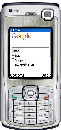
Are you familiar with .mobi (dot-mobi) yet? you know, the TDL reserved for "mobile" domains. Many inn the industry feel its pretty much un-necessary and perhaps even nothing more than another big cash grab, however, with one third of the global population -- 2.29 billion people -- connected via mobile phones today you can't really argue with the fact that maybe .mobi isn't a bad idea after all! If you'd like to see what your favorite website looks like on the latest mobile devices try out this emulator (using the spiffy nokia N70 Symbian smartphone) http://emulator.mtld.mobi/ The .mobi emulator allows you to see how Web sites look by "emulating" a real mobile phone Internet browser. Take note: many websites are not mobile compliant yet so don't be too surprised if you get errors - most popular portals will have a WAP friendly site that will be detected by your mobile browser. If you have cash to burn you can register your own .mobi domain at http://dotmobi.mobi/registrar - my personal feelings though are that its a waste of $$ why not simply setup mobile.yourdomain.com etc...
August 22, 2006
Another new CAD magazine to hit the shelves?
Roopinder picked up on this one and I have to admit, I'm a bit curious myself... WTWH Media, LLC today announced the upcoming October 2006 launch of a new engineering print public ation Design World magazine. The engineering resource focuses on serving the needs of design engineers in the medical, packaging, automotive, appliance, off-highway, semiconductor, aerospace, factory automation, and wireless markets. From the official ann.... Set to go-live October 2006, www.designworldonline.com will be accompanied by the print companion Design World going out to over 40,000 design engineers. So here's what I'm curious about... where did the 40,000 subscribers comme from? See the official PR on their blog at http://designworld.typepad.com/design_world/
A new bundle - Autodesk Government Geospatial Solution with Google Earth Pro
Autodesk, Inc. today announced the availability of a new government geospatial bundle that combines Autodesk’s powerful GIS products with Google Earth Pro. The bundle is called the Autodesk Government Geospatial Solution with Google Earth Pro, and is available on the General Services Administration’s (GSA) Schedule 70. According to the company, The comprehensive nature of this bundle supports the increasingly widespread adoption of GIS technology by virtually all government business users. Some details...
The Autodesk Government Geospatial Solution with Google Earth Pro is available exclusively to government agencies through DLT Solutions, Inc., the Autodesk Master Government Reseller. It includes the following core software applications:
Autodesk Map 3D 2007 – Delivers practical mapping functionality to engineers and geospatial professionals for integrating CAD (computer-aided design) and GIS (geographic information system) information.
Autodesk Raster Design 2007 – Provides the ability to visualize and manage raster images, including georeferenced image files, aerial photographs, digital elevation models in an integrated environment.
Autodesk MapGuide Enterprise® 2007 – Enables technical workgroups to quickly and easily create HTML-based applications that integrate numerous GIS live datasets. You can also use MapGuide to publish all your Autodesk, Intergraph and ESRI geospatial content for viewing in Google Earth Pro.
Google Earth Pro – Provides maximum ease of use for business users who require access to a blend of spatial data and integrates full-earth datasets with robust, highly detailed datasets from a variety of sources.
More information on the Autodesk Government Geospatial Solution with Google Earth Pro can be found at http://www.autodeskgovernment.com or jump to http://www.autodeskgovernment.com/default-ffye-bundles.asp
Using your mobile device to control your presentations
I know, I'm always pushing smartphones on you... the reason though is simple.. they will make your life and job much better... plain and simple! Case in point: do you ever have a need to conduct a presentation or seminar? There's a fabulous solution from SysOpen Digia that enables users of the latest N series devices fromm Nokia (like the very slick N93) to run a video presentation via a TV or overhead projector from your phone. Simply bring your phone to the presentation loaded with your MP3 and voila.. your up and running. I also guarantee that people will be coming up to you after the presentation and will want to know where you got your N93! For more on this and then some see https://blogs.forum.nokia.com/view_entry.html?id=160 / http://www.sysopendigia.com/C2256FEF0043E9C1/0/405000121 / and www.symbianone.com for a good starting point.
More MP3 players
Always a fan of electronic gadgets and the latest technology, SanDisk on Monday launched the largest flash-based MP3 player on the market (according to them) , an 8GB version of its e2xx model player. The price is set at $249 USD. I'm a big MP3 fan, however, I'm still convinced that the best deals on a multi-tasking device is to get yourself a skookum cell phone that also supports video, MP3 etc... with 5GB memory cards available its a no-brainer... plus as an added bonus, you don't have to use the incredibly annoying Apple iPod iTunes software! More on sandisk at http://www.sandisk.com/
to advertise or not?
I won't beat this one too much (obviously as I'm involved in a business that's heavily advertising based)... I was cruising some of the news resources today and ran by one... I'll call it the geo coffee shop (figure that one out)... I'm very used to online ads etc... and don't really mind all the blinking etc... but 17 ADS on one page... ouch! when I counted the banners, google ads, yahoo! ads yadayada there was 17.... I have to admit I had a hard time deciding which one I should click on ;0)
a tip - PeerBox peer-to-peer file sharing application
A tip for you mobile data hounds, check out this nifty app from PeerBox that allows searching for video, pictures and music files in open P2P networks, downloading the files onto the phone and sharing the files with other users. The app is designed for those wanting to share music, images, video etc... although there's nor eason why this couldn't be a very useful utility for sharing maps, imagery, etc... See http://www.peerboxmobile.com
Hopeworks wraps up summer season of youth involvement with GIS in the community
In a recent newsletter from Camden, NJ-based Hopeworks, some interesting project updates were offered. During the summer Hopeworks served 56 youth who earned a total of 75 college credits, worked over 2,400 hours and were paid $23,800 in salaries. Of particular interest, Hopeworks' GIS and the EPA have teamed up to survey the trees in North Camden. The purpose of this summer survey was to provide youth with an opportunity to learn about the importance of trees in our community, as well as to gather an environmental dataset for our neighborhood. The Hopeworks youth surveyors spent one week learning how to identify different species of trees and how to use the equipment needed to provide this information. Hopeworks is planning to share this data with other environmental agencies. Finally the organization also attended the 35th Annual ESRI Conference in San Diego and presented at the Education Users Conference. The title of their presentation was Creating Hope For At-Risk Youth. Kudos to a fine organization - see hopeworks.org
to google or not to google - Google cracking down on trademark
Word on the street has it that Google is starting to crack down on the use of the term "google" in domain names.. and, their winning! Example, googlecheckout.com, googlematching.com, and googleoutdoors.com was in a recent battle and lost.. apparently their defense was that they were using the term go ogle and not google.. ya right! Some are complaining that the term Google is now a commonly used verb and thus is subject to be used as such.. not so according to the courts. Should be fun to watch, however, until hten you can likely expect the likes of many blogs and domain owners containing the term "google" to be doing some serious ass kissing! More can be found in this interesting update from News.com - see http://news.com.com/Google+wants+people+to+stop+googling/2100-1030_3-6106479.html?tag=alert
August 21, 2006
More on google Earth Mobile and some cool Sci-fi Sketchup animations for your KMLs
Looking for some help on using google Earth & viewing KMLs from your mobile phone? If so then this video from the development team may help - see http://video.google.com/videoplay?docid=2705703124679991020 - even more on GM mobile is online at http://www.google.com/gmm/tour.html. Finally, for fun see how some star trek fans used their mobile handsets to view KML data showing sci-fi locales! See http://services.google.com/marketing/links/trekfan2006/ - those of you using Sketchup to enhance your KML data might be interested in somme of the cool sci-fi 3D scences that are available for you to embed in your apps and data - how about Captainn Kirk or maybe the Enterprise within your KML?? See here
Another camera phone picture sharing resource
Are you a mobile mobile blogger aka moblogger? No doubt you're familiar with Shozo (www.shozu.com) if not you should be - the app saves you precious data charges that you get slammed with while uploading data (photos, videos etc...). Obviously you can post your pics to the web (ie. your blog, flickr etc...) Today another social networking resource devoted to sharing photos is now available - Radar from Tiny Pictures. From the company... This easy, free and addictive service enables fast and simple sharing of camera phone pictures among only your inner circle. The service is in free public beta now and Tiny Pictures is working with a couple of different device manufacturers (who target the youth market) to port Radar in a highly integrated fashion to their devices. See www.radar.net - at first take its very basic and it seems to take a bit of time for pictures to appear, however, it is in Beta so maybe something cool will come down the road!
What's New in ArcGIS Desktop at 9.2 seminar
Heads-up... can't wait to see what's coming in ArcGIS 9.2? No worries, bookmark this seminar... What’s New in ArcGIS Desktop at 9.2 - showcases upgrades included with the new ESRI software, will air live over the Internet on August 31, 2006, at 9:00 a.m., 11:00 a.m., and 3:00 p.m. (Pacific Daylight time). The disclaimer... Although the seminar is available to anyone, viewers of this technical seminar should be familiar with working in the ArcGIS 9.x environment including understanding how to navigate the ArcMap interface, create symbols for data, work with tables and labels, and use ArcCatalog to manage geographic information system (GIS) data. See www.esri.com/training
Flip a coin.. heads San Diego, tails San Jose! ESRI UC 2007 and Where 2.0 conflict
oh no... 10 months away and we have a nice conflict already! Thanks to fantomplanet http://fantom-planet.blogspot.com/ for pointing out that next year's ESRI user conference (San Diego) and the very popular and cool O'reilly Where 2.0 are GET THIS... scheduled during the same week! Both of these events were scheduled by yours truly as MUST ATTEND so figuring out the logistics of this one should be fun! ESRI UC runs June 18-21, 2007, Where 2.0 is set for June 19, 20 in San Jose... which one are you going to?
3 things to remember on your next cover letter and resume
Guy Kawasaki recently devoted a whole week of blog posts to career & professional development. He had a couple of "experts" critique a cover letter and resume for a job posting. A couple of very good tips came out of this and hopefully these items may help one of you score that dream job. 3 good things to remember when you send out your next cover letter and resume:
- try to highlight what you did most recently not at the beginning of your career
- The point of the cover email is to catch the attention of the “recruiter” and entice them to read further. It should call out items of interest that would otherwise not be covered in the resume.
- What often lacks is the “so what.” If you focus on something very important that you did, why was it so important and how did it impact the company?
All good things to remember.. thanks Guy! See http://blog.guykawasaki.com/
2006 Forum Nokia PRO Awards kick off
Developers looking for recognition, validation, and some cash should take not of the latest opportunity from Forum Nokia - 2006 Forum Nokia PRO Awards - this is a great way to get your LBS or other cutting-edge mobile application noticed and fast-tracked to market. I'm pleased to have once again been asked to participate as a judge, having just come off of judging the Handango Champion Awards. FYI, the awards are open to all members of Nokia's advanced developer program, Forum Nokia PRO. More on this year's awards program can be found at http://www.lbszone.com/content/view/1199/2/ or see forum.nokia.com. Developers looking for more mobile application competitions should also look into the Navteq LBS Challenge, WINBC developer awards, Handango Champion Awards, and awards offered by Orange at competitions held at the Code Camp events.
Subscribe to:
Posts (Atom)