
August 31, 2006
how to grab attention... get bought out by Nokia!
An observation... I noticed this morning that virtually every Geo newspub has picked up on some PR about Nokia's purchase of German-based Gate5 - these guys are the developers of the smart2go travel guides - a mobile navigation solution. This is all cool but what I find somewhat odd is that we've pretty much never seen Gate5 mentioned on the "GIS" pubs prior to this eventhough they've been around for years. Now that Nokia has them it's front page news.. weird. I guess it is great for all of us though as the acquisition means that navigation will now be making it to decks as they are shipped, bringing mobile navigation and directions to the finger tips of users. FYI, Gate5 are in fact regularly referenced on LBS focused publications and ezines. I recently mention them myself on lbszone.com and symbianone.com - they were even one of my first advertisers helping to get symbianone.com off the ground. For more on Gate5 see http://www.gate5.de/
firefox2 expected today
From the mozilla wiki, firefox2 (beta) is expected to be available today - assuming no stop-ship items discovered. More details can be found in the status meeting minutes and obviously you can get more info at http://www.mozilla.org/
Public Geo data open letter translations wanted
Jo Walsh over at the free gis list has made a request for help to locate people to translate a document that will be used in a coming submission. About The public geo data open letter The goal of this letter is to ask the ministers of the 25 member states to publish their position on the 2 important amendments of the Parliament regarding exclusion rights of state collected geo data. See http://publicgeodata.org/Open_Letter_Third_Reading - the text is about 2/3 of an A4 page and would be about 10-15 minutes work.
August 30, 2006
A mashup developer tip - mapicons from TerraIMS
I just stumbled onto an interesting developer of mashups and much more at TerraIMS. These developers not only have some very cool mashups but they also have several innovative solutions including an Internet Map Server (IMS), and a very cool product called mapIcons - map marker visualization for Google™ Maps and Yahoo! Maps. mapicons includes a comprehensive library of high-quality PNG graphics files that can be used in any map 'mashup'... how sweet is that? No more boring pushpins or simple bullets, balloons or dots for symbolizing your mashup. Check out the sample map gallery including the following mashups:
State of Oregon DMV locations
Recent earthquakes around the Globe
Oh, by the way, mapiconos is totally free!! See http://www.terraims.com/
State of Oregon DMV locations
Recent earthquakes around the Globe
Oh, by the way, mapiconos is totally free!! See http://www.terraims.com/
Advanced Diploma in GIS Applications Certificate Program - Limited seats
Just a quick update from my local College on their advanced GIS Program... Limited seats are available. Malaspina University-College is still accepting applications for the September intake of this post-graduate program in Geographic Information Systems (GIS). This leading-edge program, offered at Malaspina’s Nanaimo campus on Vancouver Island, has been designed to appeal to students from differing technical and academic backgrounds. The Advanced Diploma in GIS Applications includes 4 months of intensive classroom instruction followed by 4 months of practical applications in the workplace. Students become knowledgeable in how to use ArcGIS, ArcIMS, ArcSDE and ArcOjbects. Local and regional GIS operators welcome a GIS skills-based program that uses the full suite of ESRI products. Students in the Advanced Diploma in GIS Applications program have successfully found project placements among local and regional offices of consulting firms and government agencies. For more information, please visit our website at www.mala.ca/gis or contact the Centre for Continuing Studies at 1-866-734-6252
Free surveyor Sweatshirt -- maybe if you get lucky!
 I love these kinds of gimicks... not! Check out this image I just received in some promotional effort by Prof Surv Mag. I get an email asking me to please take a survey and I can get a free Sweatshirt. Then i notice the little asterix next to the shirt and look below for more details. Then I see in something like 3 point text font the disclaimer - FIRST 50 RESPONDENTS - pretty much non-legible to the naked eye (I blew it up in an image enhancement app that I have in order to verify - see white area in image lower-left) Nice touch but personally, I'll take The American Surveyor Mag ;0)
1.4 million geotagged flickr images?
Recall I mentioned yesterday about the addition of geotagging to the flickr functionality.. well, apparently there's been more than 1.4 million photos geotagged in the past 2 days alone... wow! Obviously this is a very desirable feature. HEre's a reminder about the how to video - http://www.flickr.com/help/screencasts/vol1. Are you a flickr fan and in the Seattle area? How about attending the Seattle flickr meetup?
GISuser Magazine - in print, September 2006!

How cool is this... cover of the September issue (Volume 1) of GISuser Magazine - make sure you get a copy of this one packed full of goodies! More details on this can be found on my flickr. Actually, don't look for this on the book shelves any time soon. Rather,this image was created using a very cool flickr add-on app from fd's flickr toys that enables a user to quickly and easily create a magazine cover using any photo from your flickr photo stream (or upload one). A very cool tool
August 29, 2006
NGA Deploys DMIGS to support FEMA hurricane Ernesto preparations
In support of FEMA's hurricane Ernesto preparations, theNational Geospatial-Intelligence Agency (NGA) has deployed its newest geospatialintelligence mobile system. The Domestic Mobile Integrated Geospatial-Intelligence System or DMIGS is aself-contained vehicle custom built on a fire truck chassis that allows NGAanalysts to drive to a crisis location and provide on-the-spot geospatialintelligence analysis and products. Accordingn to the NGA, they tailored this mobile system to support homeland security missionsincluding responding to natural disasters such as hurricanes, earthquakes orother catastrophic events.
August 28, 2006
At 6:49 pm the $1600 ransom was met for the free the maps (DRG) effort
Kudos to map ransom for meeting his quota and getting all the ransom money he needed to free the DRGs. I'll be curious to see how free and available these data will actually be. Our company actually purchased Colorado DRGs from them to help with the effort - way to go Marc! See http://ransom.redjar.org/ - I'd say that mapransom owes a bit thanks to James and all the geobloggers who help spread the word as there's no way on Earth he could have done this in one day without that exposure. I'll be curious to see how long in takes to archive the entire DRG collection as there are thousands of files to get onto the server. Also, I hate to be a sceptic but when you look at things this way, the GIS community just paid someone $1600 to have access to publicly available, free DRGs which are all available for free download via a number of mechanisms. Granted, people that paid, er... donated a small fee to get DVDs containing their DRGs got a relatively good deal but didn't they just pay for free data? Isn't the ransom project all about not having to pay for free data? Something else to consider, I was looking around the site for info about the developer, JAred... I stumbled onto this piece of info in the who am I section... "Although I'm an extreme GIS neophyte, I'm starting to get a hold of some of the quadzillion concepts and acronyms. " So, once again, i hate to be a skeptic but the community just paid $1600 to this dude because he's promised to make these data freely available. Of note... does anyone out there have the USGS DEMs that they purchased - obviously, since these data are also being held for ransom by several USGS biz partners! If anyone there has the DEMs and wants to make them available please let me know or contact Jared at ransom as I'm sure he'd try to get them archived as well.
Flickr Geotagging - finally embeded in the organize tool and its a breeze!
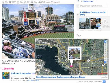 Flickr has finally made geotagging simple as drag and drop on a map... sweet! All one needs to do is go into the user "organize" utility and select the "map" tab (new). A map will be presented (Yahoo! map obviously) and then you simply select your photo(s) of choice, zoom in to a location on the map, drag and drop a picture onto the map, and that's it... sweet! Some added privacy protection has been provided so you can set geotagging to be made available to your friends or everyone. Then, when visitors browse photos, if a photo is geotagged an optional map tag will be hyperlinked to a map where the photo can be seen on a map. You'll know if a photo is geotagged if it says something to the effect of "taken in San Diego, CA" and has a "map" hyperlinked. See sample photo here. More on the flickr geotagging functionality available in the Flickr Blog or see this handy video tutorial (source of inspiration for this post was scrappad.. thanks!)
Sending products or paperwork over the border... watch out for the tax man
Is your company sending promotional material over the Canada / US border? If so then your clients may be in for a surprise when they get invoices from the courier company to pay Provincial (PST) and Federal (GST) taxes. I tell ya, this Canadian government never ceases to amaze me and I won't hesitate to tell you that the main reason I'm sooo looking forward to returning to the US to live and work.. simply put, the government here makes me want to puke! These guys can't catch people cheating on their taxes or even avoiding paying taxes at all yet they can manage to get me an invoice to $2 in taxes to be paid on an envelope i received 4 days ago that contained brochures and product specs on some hardware and a simple t-shirt. Now they want me to slap 85 cents worth of postage on an envelope and submit $2 and change to cover taxes... are you freaking kidding me???? What the hell is this going to cost in paperwork alone??? Way to promote doing business up here guys... you folks in Ottawa are indeed rocket scientists aren't you. How about the thousands of Canadians every single day that trek over the 49th parallel for cheap(er) gas and fill up in the USA, grab a case of cheap beer and come back to Canada sans duty on these products. Oh, most average Canucks will also grab a block of cheese and a few groceries on their daily trip over the border too.... however, the small business up here trying to make a deal is constantly raked over the coals... ever wonder why there's a brain drain inn Canada??? It never ends. So a tip, when you send any literature of anythinng over the border be sure to state that the value of the goods you're shipping in about $2 and no more unless you want your potential clients to get ticked off. Of note, I once had a cell phone sent to me as a trial unit and got slammed with $100 bill for taxes.. this was for a demo unit that I was to send back in several weeks... you gotta love free trade! So, I guess I better start practicing again - I pledge allegiance to the flag.....
August 27, 2006
Map Ransom and freeing the DRGs
James led me to this story and its quite cool... one individual's efforts to FREE the DRGs. In an effort billed as "Map Ransom" Jared has designed a clever initiative where he plans on raising some cash to pay for the entire catalog of DRGs.. then, once he's received enough donations to offset the expense he plans on turning them loose for free... nice idea. Jared got into this effort as after getting "pissed off" that he couldn't easily acquire public domain data (like DRGs) for free and is ticked off that resellers continue to whore out these data - anyone who knows me is well aware how ticked off I get that people are still stupidly opening their wallets to the likes of the datadepot and others to buy these free data... WAKE UP PEOPLE! Here's the speil from Jared...
Help liberate over 56,000 digital USGS maps. Donate or purchase maps on DVD to meet the ransom demand. Once the $1600 ransom is met, all maps will be handed over to the Internet Archive. The Internet Archive will make every map available for free download forever!
Users can purchase state DRG bundles for as little as $13 until the ransom has been met. Best of luck to Jared. I only hope this isn't just a clever scheme to help one guy come up with a business model on everyone elses dime. I don't get that impression and having another locale with free DRGs would indeed be a welcomed addition. Of note, there actually are loads of places where you can access Free dRG and other data (DOQs, DEMs, etc...) for example, see your state government agencies, universities, etc... many have vast clearinghouses of free data. Some examples where I've tried to help people access free data:
NOTE: In the past I've spoken to many people at various government agencies regardinng the apparent distribution of "their" data (ie... regarding DOQs, FEMA data, DEMs etc...) none of these agencies really cares who's disctributing their data. Even with specialty products and with the likes of NRCan and GeoConnections if they see a business simply repackaging data and shipping on DVDs (or CD) that is good enough for them and they see that as a value added service. So, the next time you buy a government produced dataset from anywhere, you can likely feel free to create duplicate DVDs and start giving them away or re-selling them!
Help liberate over 56,000 digital USGS maps. Donate or purchase maps on DVD to meet the ransom demand. Once the $1600 ransom is met, all maps will be handed over to the Internet Archive. The Internet Archive will make every map available for free download forever!
Users can purchase state DRG bundles for as little as $13 until the ransom has been met. Best of luck to Jared. I only hope this isn't just a clever scheme to help one guy come up with a business model on everyone elses dime. I don't get that impression and having another locale with free DRGs would indeed be a welcomed addition. Of note, there actually are loads of places where you can access Free dRG and other data (DOQs, DEMs, etc...) for example, see your state government agencies, universities, etc... many have vast clearinghouses of free data. Some examples where I've tried to help people access free data:
- The GISuser's Guide to locating and downloading Free USGS data
- GISuser Guide to downloading Free 7.5 minute DEMs
- State GIS Clearinghouse Directory - Update, July 2004
- FGDC Suggested State Clearinghouse Websites
- GISuser Guide to downloading Free 1:250K USGS DEMs
- The GISuser's Guide to locating and downloading Free USGS data (Part 2)
NOTE: In the past I've spoken to many people at various government agencies regardinng the apparent distribution of "their" data (ie... regarding DOQs, FEMA data, DEMs etc...) none of these agencies really cares who's disctributing their data. Even with specialty products and with the likes of NRCan and GeoConnections if they see a business simply repackaging data and shipping on DVDs (or CD) that is good enough for them and they see that as a value added service. So, the next time you buy a government produced dataset from anywhere, you can likely feel free to create duplicate DVDs and start giving them away or re-selling them!
Subscribe to:
Posts (Atom)