More on Geospatial Art... check out this weblog from Nikolas Schiller... he's developed some very unique and interesting Google map mashups that depict "geospatial art" as he describes it. These "quited" scenes have been developed using public domain geospatial data products from the USGS. An amazing display of art patchwork from around the country are shown.. simply pan around the map and select from the icons presented. The DC area has laods of details and lots of art work to browse... quite amazing really! See http://www.nikolasschiller.com/blog/index.php/geospatial-art/ - Green party members will love his Green party mashup!

September 22, 2006
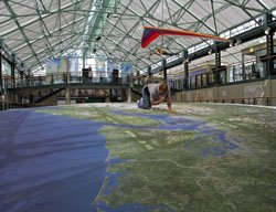
A Cartographic Excursion
NORTH, SOUTH, EAST, WESTMINSTER - Cartographic art exposition... This post borders slightly on the odd or bizarre, however, it's also quite cool... read on - for those of you in the DC area, someone has to go check this out and send me back some comments! Earlier this year, Nikolas R. Schiller was awarded a D.C. Commission on the Arts & Humanities Young Emerging Artist Grant and was commissioned to produce 8 maps of 8 locations in the 8 wards of Washington, DC. The funding allowed for Schiller to print three copies of each of the maps and in August, as proposed in the grant, Schiller donated one set of the maps to the Library of Congress’ Geography & Mapping Division, which is the world’s largest collection of maps, atlases, globes, and aerial photographs. On Sunday, September 24th, 2006 Schiller will be displaying these commissioned maps, along with other selected maps, at his local neighborhood playground. You are invited to come!
WHO: Nikolas R. Schiller, Award-winning Cartographer
WHAT: North, South, East, Westminster – A Cartographic Excursion
WHEN: Sunday, September 24, 5pm to 10pm
(Rain date: Monday, September 25 or the following rain-free day thereafter) - Monday, September 25th from 5pm to 10pm.
WHERE: Westminster Street Neighborhood Playground, Located between 9th & 10th and S & T streets, NW, Washington, DC 1.5 blocks away from the U St. Metro (Green Line)
From the author/artist/cartographer... “When I started blogging there was a certain amount of unwanted fame associated with having a heavily visited blog,” says Schiller who studied geography & computer science at The George Washington University, ”and while I wanted to share my cartographic creations with friends and family, I didn’t want it to be used as a vehicle for gaining popularity.” Instead Schiller used it as a means to document his progression as cartographer in the Nation’s Capital. His cartographic cache currently features over 100 maps of Washington, DC broken down by location, ward, and projection, and over 250 maps of locations around America, which makes Schiller one of the most prolific, but intentionally unknown, contemporary cartographers in America.
The motivator - create your own Geospatial motivational prints!
 In the "slightly off-topic" category... More fun stuff for those of you that enjoy flickr as much as I do. this fun app enables you to create a slick motivational poster to hang on the wall, use in a presentation or what have you. Motivator enables a user to quickly and easily point to a flickr photo or upload an image to the server. then you simply enter a catchy title, a catch phrase and create a frame. Then you can save, print, or upload to flickr... fun and likely some useful applications, particulalry for you geospatial evangelists... have fun with this one. See Motivator here, see my motivational poster here.
To Review or not -- Joel Rips on Sprint and the LG Fusic
A bit of fun here... To review or not to review... it's always interesting to read product or application reviews. Typically media outlets get stuck in the middle as many people request them to review their goodies.. but what to do when a big company sends you their stuff and you want to rip on it? I had the pleasure this morning of reading a weblog (Joel on software) who reviewed a "music" phone and a network service provided by Sprint and man, this guy totally ripped on the device. I have to say it was rather refreshing to see such an honest take. Here's a few tidbits from the review:
- there’s no better way to make me not want to write about something than to ask me to write about it
- The phone they sent me, an LG Fusic, is really quite awful, and the service, Power Vision, is tremendously misconceived and full of dumb features
- Overall this phone seriously looks like a Fisher Price toy
- I have literally never seen such a useless MP3 player
- No amount of pampering bloggers and calling them Ambassadors is going to get around the fact that you’re sending us plastic junk phones that look like bath toys
Wow.. talk about being honest! Anyone care to have this guy review your app or device? I dare you ;0) - See the review at http://www.joelonsoftware.com/items/2006/09/19b.html
Compliance with Open Source licensing
Roger Longhorn shares an interesting read regarding Open Source software in a recent thread to the Freegis-list. He references some licensing issues from this month's WIPO Newsletter for SMEs... "Continued acceleration in the use of open source software has made developing and implementing an open source compliance program a business necessity. While using such software, however, most companies do not
take any measures to comply with the requirements of open source licenses. This may result in unintended violations of open source licenses and other potential liabilities. To avoid this risk and also to realize other benefits, the author Jason D. Haislmaier, a partner in the Intellectual Property Group of the law firm of Holme Roberts & Owen LLP, identifies the best practices that companies could use to close the
*open source compliance gap*." See the paper at http://www.hro.com/pubs/closingthegap.pdf
A smartphone tip - Woize (think mobile Skype)
From our mobile resource comes word of a very cool application that is reported to provide free WiFi enabled calling between users... the Woize BETA client for Nokia phones with Symbian OS 9.1. The app is supposed to come in Q4 and will provide free calling for users who install the app on the Symbian OS smartphone. See more details in the PR of jump to www.woize.com
Any uses for Windows Live writer?
Just curious but is anyone out there using the Windows Live writer for anything? I noticed Jeff tested it the other day. I have to admit that I installed and tested it way back and since then have not really found any useful reason to go back and use it again. I have to admit that my PC was getting really bogged down and running like a gutless pig so during my weekly clean-up, defrag, yadayada I removed all the malware, crapware, spyware and whathave you... on the list of things that went included the Live writer app. I guess if I was an avid user of "Spaces" I'd likely find it a bit more useful - see http://windowslivewriter.spaces.live.com/ for more on this topic.
Raster data freaks can now go and Rasterbate!
Thanks to our friends at VerySpatial for a tip about this cool app... the Rasterbator. I have to admit I pretty much spewed coffee all over my Dell 6000 when I first read about this one! The rasterbator rasterization service does to rasters in their terms "rasterbation"... what a great keyword for the Glossary! Here's the skinny... The Rasterbator is a web service which creates huge, rasterized images from any picture. The rasterized images can be printed and assembled into extremely cool looking posters up to 20 meters in size. You can go Rasterbate at http://homokaasu.org/rasterbator/
Jason's notes from FME user conference - Vancouver
Leave it up to Jason Birch to provide us with an update from the FME user conference taking place yesterday and today in Vancouver. Jason gives a brief run down about the event including reports on the intro plenary, some session notes, a report from FME Idol and more... great stuff Jason! An interesting pointer to some FME art and JAson's always candid but up front comments are a welcomed addition to the blog... I like the note to Autodesk! See Jason's FME notes here. Always tough to get up to the minute event info, I'd suggest down the road organizers like this and others might look at posting a team event blog where their crew can blog away from the event. O'reilly does this for all their conferences and its awesome! ... or, maybe invite yours truly to the event and I;ll be glad to blog for you ;0)
Bowling Green prepares new Geospatial Sciences Program
Looks like Bowling Green's School of Earth, Environment & Society (SEES) is nearing completion. The new school will offer new and innovative multidisciplinary programs that highlight the commonalities between the academic disciplines while maintaining undergraduate degree programs in Geography, Geology, Environmental Science, and Environmental Policy. The graduate program in Geology will continue to offer an MS degree, and beginning in Fall 2006, a new graduate certificate program in Geospatial Sciences will be offered by the school. The school has also just announced a new faculty position for the program - see http://geology.bgsu.edu/sees/
September 21, 2006
A cool GIS career opportunity for a developer and mashup artist!
Not something I usually post here, however, this career opportunity is simply too cool not to share! The Atlanta Journal-Constitution has just posted a great opportunity for a GIS developer... some details - This position will provide a great platform for an imaginative GIS technology expert who sees the editorial and advertising opportunities in mash-ups for enhancing user engagement with geo-coded content, both for web distribution and in mobile applications. Complete details can be found here in our career center... good luck! (PS: remember that career posting is totally free at the GISuser career center - shameless plug!)
Google trends on Maps and Canadians
Poking around Google Trends, I entered a few terms and found something interesting.. what is it about the term "maps" and Canadians? Interesting to notice that many of the top 10 locations where searches for maps come from are in Canada. Ottawa, Calgary, Vancouver, and toronto are all in the top 10... Do Canadians get lost more often or are they simply more interested in geography?? hmmmm. See the results here - for fun, how about this trend of ESRI vs Autodesk - not very useful but kind of interesting! Finally, the trend in a search for GIS Data tells us that most searches for this term come from Fort Collins and Denver, CO
Cities Database Free Edition
Another POI database is on the market in the GeoDataSource Cities Database product. The company has several flavors that run as much as $1,000+. A free product is available to those who register. It contains 2 million+ city place names. Not sure how this product differs from some of the widely available free place name products available. See more at http://www.geodatasource.com/cities-free.html - other free place name products can be found here & here for those interested - there's also the ever popular GNS names server at http://earth-info.nga.mil/gns/html/index.html
BC Experience bankruptcy means the end of the line (likely) for World's largest 3D map
 Recall the BC Experience... you know, the massive 3D map of British Columbia on display in Victoria BC, Canada at the heart of a new tourist attraction - Victoria is a big tourist destination (a scaled-down version was on display in San Deigo at the ESRI conference map gallery). Well, unfortunately, poor planning and some bad luck on the part of the company that launched the tourist attraction has resulted in some financial woes. Looks like bankruptcy is a likely scenario in the near future as the venue is in debt to the tune of some $8.5 million owed to more than 228 creditors. The anchor attraction at the venue was the World's largest solid terrain model - a 40-foot by 74-foot, three-dimensional, full-color model of British Columbia. The British Columbia model is larger than a "doubles" tennis court and is the world's largest physical-terrain model ever created from digital data sources. The 3D model was created by California-based STM - complete details on how the model was built can be found here - http://www.gisuser.com/content/view/9216/
September 20, 2006
Zillow opens database to the public - more intellilgence now in Z2
Zillow.com announced the opportunity for consumers to contribute updated and detailed information about their homes to Zillow's national database. Homeowners can add features such as a recent kitchen remodel, deck addition or parking, and create their own estimate based on inside information not included in public record. By opening up its expansive database, Zillow makes homeowners a more active part of the Zillow community, letting them tell others, directly, all about their most important asset: their home. A cool addition to this popular resource - see more at www.zillow.com
September 19, 2006
Photographers - take note of this cool contest and share the experience
Just found this one from the BLM website - The Share the Experience Photo Contest is the official photo contest for the new America the Beautiful - The National Parks and Federal Recreational Lands Pass. ter the "Share the Experience™" Photo Contest for the chance to have your photograph featured on the 2008 Federal Recreational Lands Pass - other cool prizes include an SUV, digital cameras, and photo gear... I'm all over this one! Good luck - See http://nationalparks.eprize.net/experiencephoto/
Global Hotelindex uses Google Maps to provide a fast, user-friendly experience
An interesting "mashup" launched on a popular tourism portal at the global hotel index uses Google maps to power a search of more than 500,000 hotels around the Globe. At first glance the site offers a nice flash-based mapping interface... drill down a bit further though and get hits supplied via a google map. The presentation is really nice in this app, mouse over icons reveals more information and online booking is just a click away from your hits. This is definitely a nice commercial app using the Google map API... well done. See for yourself at http://www.globalhotelindex.com - FYI, Global Hotelindex is a privately held company, focusing on hotel search services and tourism-related advertising.
Any updates on the Free DRG project?
I'm curious, has anyone heard anything about the progress or plans to make the DRGs freely available via the Internet archive? Recall the plan from few weeks ago where Jared bought the DRG collection from a vendor, collected "donations" from the industry and then told us that the data would be made publicly available in a handy location (I still contend that they already are publicly available) . I've contacted them a couple of times requesting a simple update or any information at all but have not heard a word - although a small mesage on the site states that the data has been delivered. Now, don't get me wrong but won't uploading and indexing thousands of DRG files take considerable effort?? Until them a few free DRG resources can be found here and there's also the fabulous Geospatial Data Gateway - Have you heard anything? Related weblink http://libre.redjar.org/maps/
September 18, 2006
Manhattan Story Mashup - the urban photo hunt
Manhattan Story Mashup is an urban game, taking place on September 23rd 2006 in Manhattan, New York City. During the event, approximately 250 players will move around Manhattan, taking photos which match a given target. Targets are words from stories, written by you and other visitors on this web site collaboratively while the game goes on. The resulting illustrated stories are shown on large public signs in Times Square in real-time and on the website at http://www.storymashup.org/
Manhattan Story Mashup is organized by SensorPlanet, a Nokia Research Center -initiated research program on large-scale sensor networks. See also the behind the scenes pages at http://www.storymashup.org/msm_background.html. More about the event from Nokia Research... The objective of the game is to build stories in a collaborative fashion: the players take pictures while wandering around Manhattan, triggered by the keywords picked up by the participants on the web. The collected pictures and the keywords are eventually lined up to form several tiny stories, presented as the final outcome of the game in one of the large displays at Times Square. See http://research.nokia.com/
Manhattan Story Mashup is organized by SensorPlanet, a Nokia Research Center -initiated research program on large-scale sensor networks. See also the behind the scenes pages at http://www.storymashup.org/msm_background.html. More about the event from Nokia Research... The objective of the game is to build stories in a collaborative fashion: the players take pictures while wandering around Manhattan, triggered by the keywords picked up by the participants on the web. The collected pictures and the keywords are eventually lined up to form several tiny stories, presented as the final outcome of the game in one of the large displays at Times Square. See http://research.nokia.com/
September 17, 2006
Free GIS Data GeoBlog
GIS users are always searching for free data sources. There's plenty of them out there but locating them can be a challenge. Many of you know that we already have hundreds of pointers to great free data repositories listed in some of the directories and articles hosted at GISuser.com. In an effort to share all the great pointers that we have I've started migrating pointers to some of the best free GIS data resources in a new blog - aka. the Free GIS Data blog - look forward to the best of the best making their way to this directory and feel free to suggest additions. Categories will make searching the blog a breeze with geographic tags (ie. State name or country) and by data type (ie. DRG). hopefully this resource will be useful to the community and I look forward to it growing nicely in the near future. The focus of the data resources will initially be on US data sources (ie. places where you can grab free DRGs and DOQQs) but there's also some great Global data resources as well. Bookmark http://gisdata.blogspot.com
Google free data crawl updated - LIBRE scores top spot
I have to say it makes me pleasantly happy to see that the ever entrenched "datadepot" has finally been replaced on Google's search crawl when you search for a common term like "free Alaska DRG" - in the olden days a search like this would always turn up the datadepot as the number one hit - actually they would typically yield about the first 3 hits due to the way the site was initially created, using a number of pages all with the same meta tag info that you would have to painfully click through in order to get to your intended destination. Now it seems like other resources which are actually FREE have taken over the top spot... most notable, the LIBRE free DRG map project seems to have secured the number one position for this term for every State... hopefully the data will actually be freely available there in the near future! Also noteworthy (you know i love knocking the datadepot), the depot and their sites appear to have taken a freefall inn the Alexa rankings in the past few months (sweet!) - I'm outta here - PS: a side note.. if you're interested in getting in on a free parlay bet each week for NFL football check out sportsbook.com - good luck ;0)
Why free GIS data is so hard to find! Error 404
We all know that free GIS data is abundant, however, why is it still so hard to find and why is there so much confusion? I'll tell you one HUGE reason... the bloody links to spatial data repositories are constantly coming and going... dead weblinks with no paper trail or forwarding link are commonplace. I have a number of directories that I've created over the years - like this one - (as do many others) but the links are typically out of data after a year. A few examples.. this pointer to a Colorado clearinghouse (page not found), SC department of natural resources (page dead), or how about this fabulous link to the datamil in Delaware which now leads us to a page that simply tells us to go away... nice! It never ceases to amaze me how a fabulous data resource can be easily found one day and then simply removed or moved the next with no forwarding link. This is but one of the huge problems that we are facing but has a simple solution... provide a simple page forwarding link or redirect when you move or replace a website... it's not rocket science!
Subscribe to:
Posts (Atom)