
October 14, 2006
The importance of tags - a note to event planners
Something i was just thinking about as I searched the web for information from a past event... why aren't event planners taking advantage of tags? A note to anyone planning conference and events, when you issue your PR and publish your event website I suggest you considefr using an "official" tags that you suggest people use when referencing and publishing material about your event. It sounds like a no-brainer but not many folks are doing it -- except maybe O'reilly. I recall Where 2.0 last June (or was it May) and the conference organizer maded it very clear that if you were blogging or publishing material about the event they suggest you use the tag "where2006". With all the people blogging, using flickr, indexing material on digg, technorati, and del.icio.us it would make life much easier if everyone was on the same page and using the same tags rather than making up their own. As an example, last year I moblogged loads of photos from AU in Orlando. they were tagged with many tags, including "au2005". Searching flickr using this tag yielded many hits, however, what about photos from the event that didn't have that tag? See http://flickr.com/search/?q=au2005 as a sample search. Curiously, nothing on digg is found using au2005. Imagine... "AU2006" the official tag of Autodesk University... sounds like a great idea to me!
$2 million to update and maintain USGS website!
Oh man, talk about a nice score... the USGS has recently awarded a contract for $2 mill to a company to revamp and maintain their website... maybe I'm missing something here but holy crap, sounds like alot of dough... I'm sure somme of you would like to have a piece of this one! Mind-you, they do operate numerous sites so no doubt there's much more to this than simply designing and updating a little website. I'll be really curious to see what $2 million worth of website will provide... no doubt some skookum webmapping services etc... more on this at FCW - see also the PR here
Testing geocoder US and the Yahoo! Maps Web Services - AJAX API
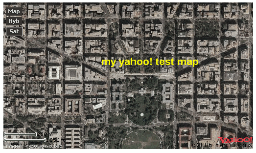
Killing a bit of time here while watching a little NCAA football this morning, I ran into some info from the Yahoo Local weblog. I decided to request an application ID and test out how long it would take for me to create a simple little map using ylocal. The App Id request took me about 5 seconds once I signed into my yahoo account (don't have one yet??? where have you been!) I then grab a little bit of sample code provided by a tutorial describing how to get started with the Yahoo! AJAX API - see here. In no time I simply substitute my ID for the generic one listed in the sample and voila. I can now easily resize and re-center my map and the updates are reflected on my web page. All I need now is to geocode an address and reposition my map... this is easily done using the app provided at http://geocoder.us/. Let's see now if I can place the map here within the blog... hopefully blogger will accept the code... oops.. looks like I can't embed the map within the blog post, however, I do have an html page that I could easily add to a website. I have to wonder if Google doesn't allow Yahoo! maps to be embedded within their apps.. ie. like this blogger weblog!Given that it took me about one minute to create I could easily start messing around and customizing the map if i was to dig deeper into the sample code and tutorials. See http://ylocalblog.com and try for yourself. Register your API app and get a code
zonetag your photos and blast em to flickr - a project from Yahoo! Research
More on flickr as I recently installed and tested ZoneTag. This cool and free application (from Yahoo!) enables users to automatically have their photos tagged with geographic information (geotag) based on cell ID. I'm still on the fence as to this app is really goint to be that useful, however, I'm sure some savvy programmers will come up with some cool uses of data that has been zonetagged so I'll hold out until then until I comment further. Using the app was very simple and the install and configuration was no problemmo. I noticed that I seem to be the only one using the service from canada so far (try this search for zonetagged photos from Canada - http://zonetag.research.yahoo.com/photos/index.php?time=7&city=&zip=&country=Canada&flickrname=&tag=&showmine=1&group=everyone) . Notice that my photo has been automatically tagged with the following:
Zonetag
cameraphone
Canada
celltagged
cell:network=
cell:mcc=302
cell:mnc=720
cell:lac=9800
cell:cellid=53361
cameraphone
Canada
celltagged
cell:network=
cell:mcc=302
cell:mnc=720
cell:lac=9800
cell:cellid=53361
How it works is the app depends on the users to add additional information and then the cell ID is updated with the information provided. So, if I add a postal code or city name (Nanaimo) to my tags zonetag will incorporate that information in future uploads. I nice starting point from Yahoo! Research - see http://zonetag.research.yahoo.com/. Something I haven't figured out yet though is how I can use the functionality of Shozu with zonetag? Will they compete with each other? Obviously, with so many flickr users depending on shozu to save on data throughput and those nasty charges I would think that incorporating zonetag while using shozu would be critical. You can see my zonetagged photo at http://www.flickr.com/photos/gisuser/268909916/
Saving cash photo blogging with shozu
More mobile tips for you.. well I finally got Shozu loaded correctly on my mobile.. woohoo! I've been trying to get it right for several months now. The problem I had was with the WAP download service setup on my device. I managed to get around it by getting a .SIS file downloaded directly to my PC and then installing from there rather than directly from the device OTA. Anyway, if you use flickr, or moblog photos from your camera phone (you do have a camera phone right???) then Shozu is a must have. The application is free and it crunches your data for efficient distribution to community sites like flickr, Kodak easyshare, webshots and others. You can even configure shozu for efficient sending to FTP sites, your blog or via email. Of note, I have noticed recently that configuring apps like this for Blogger (Beta) is not possible. The problem seems to be that with Beta a user (like me) can own a number of blogs. The configuration setup of third party apps seems to freak out when trying to ping Blogger Beta for the setup... darn! Just as well I guess as the last time I was uploading photos directly to the blog from my phone the planet geospatial news feed was totally freaking out (a guaranteed way to get James out of bed ;0). So, the long and short of it is check out shozu.com to save on those nasty data charges from your mobile provider... it cost me about $100 in roaming data charges last time I photo blogged from the ESRI UC.. ouch! You can check out my flickr blog at http://www.flickr.com/photos/gisuser/
October 13, 2006
ASPRS Provisional Certification program in Photogrammetry
ASPRS has developed a Provisional Certification program in Photogrammetry, Remote Sensing and GIS/LIS that is now available to graduating students in the spatial sciences who meet the educational and program requirements. The first of its kind, this program provides students with the opportunity to take the ASPRS certification exam as they are finishing their studies. Eligible students can apply, pass peer review, and take the examination in their specialty (Photogrammetry, Remote Sensing, or GIS/LIS) while still in school, and become “provisionally certified.” More details at http://www.asprs.org/membership/certification/certification_guidelines.html
Some mobile mapping updates from Google, Palm, Nokia
A few news updates for you mobile enthusiasts looking for mobile mapping applications and the like... Google has partnered up with Palm to offer users of the Treo access to the popular Google Mobile - think gmaps on your phone. Google Maps for mobile has been optimized for the following Palm OS based Treo smartphones:
New Treo 680 smartphone
Treo 700p smartphone
Treo 650 smartphone
Treo 600 smartphone
Google Maps for mobile is available today free of charge. To download Google Maps for mobile to a Treo smartphone, users simply visit http://www.google.com/gmm
Speaking of mobile search, Nokia has added to their mobile search portfolio with the addition of new services for Canada, Denmark and Germany. Mobile Search is available in select markets in the standard sales packs of the Nokia N80 Internet Edition, Nokia N73, Nokia N93, Nokia N70, Nokia N71, Nokia 6630, Nokia 6680, and Nokia 6681. It is also offered as a free download for more selected Nokia S60 devices from http://www.nokia.com/mobilesearch.
AutoCAD 2007 screencast
We've heard of webcasts, podcasts, vodcasts yadayada.. how about a screencast? Now you can Tour the new features in AutoCAD® 2007 software and get valuable, time-saving tips from AutoCAD guru Lynn Allen. This "cast" is fast and pretty slick.. almost as good as seeing Lynn in person! Check out Lynn as she walsk you though some of the cool new features in the product... a great example of how technologycan help you promote your applications or services. See http://clk.atdmt.com/CIK/go/clrnkptd0100000007cik/direct/01/
California First Amendment Coalition sues County over access to digital mapping data
This interesting tidbit from the Mercury News... a group is seeking to break up what it called a "government monopoly" on the county's digital mapping data. At the heart of the matter is the fact that the County is charging hefty fees to access the so-called "base map" of the county's geographic information system, or GIS. Santa Clara claims the data is copyrighted and proprietary - Gee.. when have we heard this before! It amazes me to no lengths how many government agencies are locking up "THEIR" data and stating that base maps are copyright and proprietary. See details at http://www.mercurynews.com/mld/mercurynews/news/breaking_news/15737626.htm
USGIF Funds for Earth-Science Educational Materials
The United States Geospatial Foundation (USGIF), through its recently created James and Susan Clapper Education Initiative Fund, has raised more than $1,600 for area schools to purchase educational materials relating to earth-science studies such as maps, geological tools, compasses, books and related software. Schools interested in using this money should write the USGIF and provide the school’s name, demographics, and a summary of how much money is needed, how the money will be used and who will benefit. Requests should be mailed to USGIF James and Susan Clapper Education Initiative Fund, 2325 Dulles Corner Blvd., Suite 500, Herndon, VA, 20171. The deadline for applications is Friday, Nov. 3. See http://www.usgif.org/ or check out the full PR at http://www.gisuser.com/content/view/10040/
Home Rental Property mapVine - free mashup service for property rentals
Dave over at the mapVine blog tells me about a newly developed free property mapping tool designed for the real estate sector. mapVine allows a web site owner to quickly create a map using Google Maps technology for their web site with little or no programming knowledge. Users setup a simple, free account and select a login/pw pair. then you simply start adding your rental listings. Currently the service is only for US properties but maybe that will expand down the road. You can check out the mashup and register to post at http://www.rentvine.com/map/. To test the waters I created a simple map using details of a property on craigslist.. see below... it took about 30 seconds for me to complete. Once done I'm provided with the code to embed the listing on my website... nice!
October 12, 2006
looking for GIS RFPS.. save your cash and go to Merx or fedbizopps
Looking for GIS / Geospatial RFPs and bids? Its quite funny but there's people out there actually paying $$ for geo bids services... what are they getting? All they get for xx$$ a month are RFPs that are listed on public bid sites. I'll save you some cash. You can get them for yourself at www.merx.com (Canada) and fedbizzopps for the US see http://www.fedbizopps.gov/.. save your cash! I can only assume that the people paying for this free service are the same ones that keep on buying free data ;0) Speaking of free data.. here's an updated list of links to most of the State GIS clearinghouses.. enjoy! See http://gisdata.blogspot.com/2006/10/updated-state-data-centers-and.html
More on the Canada Map Office closure
Ironically, just this AM I heard from a discussion list that the decision has been reversed... now just today the CBC is reporting about the decision to halt printing of paper maps (see http://www.cbc.ca/canada/north/story/2006/10/11/topo-maps.html). I'm curious how some of you professionals feel about having access to paper maps. Its been a number of years since I've had a need to buy paper maps. In the past I've digitized features directly from them and I've also had a need to b uy paper hydrographic charts. However, it seems that most of the general population really doesn't have much of a need for access to paper maps. Does it really make sense to have an entire government agency setup to handle/manage/administer this service? I fail to see how providing the public with access to an efficient online service where PDF maps can be downloaded or ordered online cannot substitute for this service? Providing options to purchase low quality or high quality maps would be a nice service, likewise, printers could also provide other options such as print on acid-free material, print on cheaper paper stock etc... Do you think this service could be effectively managed by an online service provider or regional resellers?
CanadaMap Office to Remain Open (for now) and printing Paper maps
This update has been circulating on some of the various Canadian map library and geography lists regarding the closure (make that non-closure) of the Canada Map Office. This comes from the GIS Coordinator, Maps, Data and Government Information Centre, Carleton University Library... On the morning of October 11, 2006 the Map Uses Advisory Committee was contacted by Kathleen Olson, Acting Director of Communications to the Minister of Natural Resources. Ms. Olson wanted to make key stakeholders groups aware of Minister Lunn’s recent decision to keep the Canada Map Office open. According to Ms. Olson, “as soon as this was brought to Minister Lunn’s attention he recognized the need to continue this service to stakeholders and Canadians”.
So, for now it seems that a vocal group of mapping professionals and academics have halted the closure of the Canada Map Office which would have meant stopping the printing of paper maps by the Government agency. Apparently the thought of regional partners and agencies handling the on demand printing service was not a suitable option for many so for now the offics remains.
A visit to the map office home page (http://maps.nrcan.gc.ca/distribution_e.php) provides this message: Customers are reminded that the Canada Map Office no longer distributes maps directly to the public. We recommend the purchase of National Topographic System maps, aeronautical charts, and National Atlas of Canada publications from any of over 900 map dealers across Canada, the United States and overseas.
October 11, 2006
How to form a geography club
An interesting primer from the National Council for Geographic Education (NCGE) introducing readers on how to form a geography club in a school. The detailed documents cover off everything you can imagine from getting started, materials needed, activites, resources, and much more - nine months of activities are provided. A great bookmark for any young geographers. See http://www.ncge.org/resources/geoclub/
Share your docs using Google docs
More cool features coming from Google... this time its Google docs and spreadsheets... use your Google account to upload, view, edit, and share your Word documents, Excel spreadsheets, and other important docs. Edit online, invite others to share your docs and publish to your weblog. Check it out at http://docs.google.com/
GISuser news roundup for Wednesday
I was just thinking that I often promote other people's stuff on the blog but what about all the great stuff that we offer? Therefore, here's my very own shameless plug for today's edition of GISuser Today - the must have GIS industry newsletter. A simple reminder about our 3x a week GIS industry news roundup... just published this AM is our latest edition. Today I share with you some updates about our free GIS tools repository (Can you believe there's more than 800 pointers in this mammoth directory!). A primer on Geocaching (this is a very basic primer i.e.. Geocaching 101) is discussed in our spotlight today. The industry news update features words from Idelix who've introduced the Idelix Labs (devzones are a think of the past, its now cool to have your own Lab!), Trimble is promoting a new GPS Survey system, how about a Lidar extension just for ArcGIS users?, speaking of LIDAR, we also have news from the organizers of the very cool ILMF event (I was at this year's event in Denver and it was awesome!)... in addition to these updates you'll also find a lead from our friends Chris at GlobExplorer who's wanting us to spread the word about a cool job opportunity for a GIS professional in their Walnut Creek, California office, an event reminder is presented from Autodesk who are running yet another free webcast by "Pete" all about the advantages of using Autodesk Map 3D 2007. This edition of the newsletter is archived online at http://www.gisuser.com/newsletter/oct112006.html - check it out and register to receive it in your mailbox if you find something useful
iMapBC website honored by ESRI Canada
Congrats to the BC Ministry of Agriculture and Lands - Integrated Land Management Bureau (ILMB) who was recently presented with an Award of Excellence at ESRI Canada's annual conference in Victoria BC, Canada. iMapBC is based on ESRI's ArcIMS technology and the Internet Mapping Framework (IMF) developed by the BC government (in collaboration with Moxi Media Inc.). It includes functionality and access to data that goes far beyond a typical internet based mapping application. From the internet browser, users are provided with a base map and can select map layers to add to the map. For more information on the iMapBC website see ww.nric.ca
Google introduces Code Search for Programmers
Google is introducing a new search service -- for computer programmers. See http://www.google.com/codesearch - The Web search giant said it is introducing Google Code Search, a site that simplifies how software developers search for programming code to improve existing software or create new programs. Google product manager Tom Stocky said the Mountain View, California-based company is set to help programmers sift through billions of lines of computer source code using its familiar search box to uncover snippets of reusable software.
October 10, 2006
testing Open Layers Map Viewer Service
Just messing around, watching the Tigers spank the A's and testing this Open Layers app... see http://openlayers.org/ for more info. The map shown below is easily embedded within any webpage... simply copy and past the code provided. More info includinng a tutorial is available from the Open Layers website... NICE! FYI... OpenLayers is a pure JavaScript library for displaying map data in most modern web browsers, with no server-side dependencies. OpenLayers implements a (still-developing) JavaScript API for building rich web-based geographic applications, similar to the Google Maps and MSN Virtual Earth APIs, with one important difference -- OpenLayers is Free Software, developed for and by the Open Source software community.
width="450px" height="200px"
scrolling="no"
marginwidth="0" marginheight="0"
frameborder="0">
width="450px" height="200px"
scrolling="no"
marginwidth="0" marginheight="0"
frameborder="0">
LP360 LIDAR extension for ArcGIS
LIDAR users will be interested in this announcement from QCoherent Software. They've announced the release of LP360 version 1.3, the LIDAR extension for ArcGIS. LP360 employs a specially designed ArcMap™ data layer to access and draw LIDAR points directly from LAS files You can check it out at www.QCoherent.com or jump to the announcement at http://www.gisuser.com/content/view/10006/
Navizon API: one for the Web and for Mobile devices
Mexens Technology today announced the availability of two new versions of its Navizon API: one for the Web and for Mobile devices. Starting today, businesses with an online presence can use the power of the Navizon positioning system in their own web based applications. By triangulating the signals from surrounding Wi-Fi access points, the Navizon Web API will identify the exact location of the end user in order to provide him or her with a targeted location based content. More details can be found on these new products at the following address where a live demo is also available: http://www.navizon.com/developers - or see the announcement at http://www.lbszone.com/content/view/1323/2/
GIS blog and news updates for Pocket PC users via Hubdog
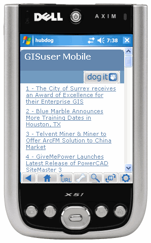 Here's a useful app for any content publishers and even you geobloggers out there... enter HubDog. Hubdog enables bloggers (and other content providers) to easily publish mobile RSS feeds. I've created a mobile feed for GISuser.com news updates - you can grab this and take your GIS industry news updates to go. Simply visit http://www.hubdog.com/c/36218/preview to get a preview. If you realy want to take this blog on the road with you HubDog are updates are also now available for this weblog (link). This free RSS reader from Hubdog lets you listen to Podcasts, watch vidcast and other web content directly on your smart phone or mobile device. For more about HubDog see http://www.hubdog.com/
October 09, 2006
MyOutdoors.net mashup relaunches with new design
MyOutdoors.net has launched the new redesign this weekend with loads of new features, like as GPX upload/download, elevation display, and full text search, all in an effort at making the user experience as smooth as possible. There's also a blog post about their experiences doing the redesign at http://myoutdoors.blogspot.com/2006/10/lessons-in-web-20-design-myoutdoorsnet.html - See MyOutdoors.net for more
Subscribe to:
Posts (Atom)