

November 17, 2007
New - The Autodesk / AutoCAD zone on GISuser
We're slowly aggregating cool content on GISuser into specialty "Zones". The latest Zone to be added is the GISuser Autodesk zone... this is where you can browse all the AutoCAD / Autodesk related content that we've developed over the years. Check it out to access articles, spotlights, news, images and more all focused on Autodesk geospatial solutions like MapGuide, Map3D, Civil 3D, DWF and more. Jump to the Autodesk Zone here

November 16, 2007
Online collaboration and publication the web20 way with Scribd
Here's another one of those way cool Web20 apps designed to facilitate online publishing, file sharing, and even content syndication. Scribd provides users with a simple, easy to use UI for uploading common file formats (word docs, PDFs etc...), build a library of articles, then share and distribute via your library. Once online you can even embed your document onto your website or blog for viewing... pretty darned cool and the potential uses are quite lengthy! See www.scribd.com
ExploreThe Earth With Earthcomber - Local, Mobile Search Done Right!
Nokia N95 Suggested Application... I recently added a nifty location-aware search application to my mobile device (Nokia N95) which I discovered via the Nokia Content Discoverer ... aka. content downloader application. Earthcomber enables local search and takes advantage of the built-in GPS that comes with the Nokia N95. Read on for more on this cool, must-have mobile application for anyone who's using a GPS smartphone like the N95, N82, or E90

read more | digg story

read more | digg story
10 Cool reasons to migrate to MapGuide Enterprise
Based on MapGuide Open Source, Autodesk MapGuide Enterprise offers simple deployment and helps streamline the development of web-based mapping applications. Did you know that Autodesk MapGuide Enterprise also allows users to directly publish MapGuide maps and layers to Google Earth? Read on for 10 Cool reasons to migrate to MapGuide Enterprise, Some of the Major benefits of MGE 2008, and features of Autodesk MapGuide Enterprise 2008
read more | digg story
read more | digg story
Virtual Earth interactive SDK and eVA emergency procurement demo
If you want to mess around with Virtual Earth a little then the VE for Government blog has pointed us to some fine resources of interest. For starters, the Virtual Earth interactive SDK lets you test some of the functionality, complete with video tutorial and online help. Taking this one step further, a full-blown active site showing some of the things you can accomplish with the SDK can be found at the eVA Emergency Procurement Mapping System (BETA) website. The application is meant to help users locate essential items during a time of crisis.


November 15, 2007
Local Pizza Search - loads of hype but a little Cheezy!
Is there really a business model in searching for Pizza?? Thanks Adena for picking up on this "news" about a local search designed to connect people to pizza joints near them.. too bad the results are, well... crappy, to say the least! The company even went as far and issued a press release that even promoted this ... Pizza.net is leading the way in search technology! Sorry, but I have at least 5 mobile local search applications that give me way better results that this application so how they manage to lead the space is of interest to me! If I want to locate pizza, chances are I want to do it from my phone... I can easily use Google mobile search, Google 411 (free calling service) and excellent local search tools and widgets from the likes of boopsie, earthcomber, gmaps mobile, nokia maps WHERE search widgets and many others. Like Adena, the results I got were, well, od to say the least.. the top results are not close to me and the distance provided was not accurate, many results all being 3.6 miles away when I know some of them are less than 2 miles, others more than 7 miles away! The idea of just searching for a particular style is cool.. ie. New York but until there's more community feedback I really don't see this as being very useful - try for yourself at http://www.pizza.net
New Social Networking, Data Sharing Capabilities For Recreational GPS Users
LocationNation... for hikers, bikers, travelers and adventurers of all kinds, LocationNation today announced the release of the GeoSpatial Media Organizer (GSMO), a free online service for managing and sharing personal Global Positioning System (GPS) data. GSMO is available at no charge through http://locationnation.com and includes unlimited Internet Map Server (IMS) usage, providing street level data and aerial photo maps. Users get complete access to user communities, where they can create communities, invite guests and display features on a map, as well as 50Mb of free server space and a free download of GPS Connector for hassle-free GPS data transfer. GSMO works with any Garmin or Magellan handheld GPS device.
read more | digg story
read more | digg story
2008 Geomatics Engineering Conference - Jan 24-26, 2008
Event of interest - The Geomatics Engineering Conference at Fresno State is facilitated fully by the students in the degree program seeking a B.S. in Surveying and Photogrametry. This conference raises scholarship money for the students in the program. It is also one of the biggest conference in California with a focus of surveying. See http://www.csufresno.edu/geomatics/conference/
November 14, 2007
Terabytes of Ready-to-Use Data for ArcGIS Server - Data Appliance
This out of Redlands today... ArcGIS Data Appliance combines data and hardware that easily connects to an organization's existing IT infrastructure. Multiple divisions, departments, and client applications are now able to efficiently share a common information architecture and set of mapping and visualization services and combine those with a user's own data. Users can also add their own tasks and fuse them with content from ArcGIS Data Appliance to conduct visibility modeling, proximity search, or demographic analysis.

The data collections include
World Collection—Includes satellite imagery for the world down to 15-meter resolution and a seamless world street map with highway-level data plus shaded relief imagery, physical and topographic maps, and a political atlas map for the world.
USA Prime Imagery Collection—Comprises more than eight terabytes of data and includes a seamless mosaic of 1-meter resolution or better aerial imagery as well as detailed topographic maps down to 1:24,000 scale for the contiguous United States along with satellite imagery for the world at 500-meter and 15-meter resolutions for display at smaller scales. The high-resolution imagery is a color mosaic of commercial and government imagery sources including recent submeter commercial imagery for many metropolitan areas and the best available government imagery for other areas.
USA Imagery Collection—Includes an offering similar to the USA Prime Imagery Collection in a dataset that is more than six terabytes, with 1-meter resolution imagery from the best available government sources and detailed topographic maps but without the recent submeter commercial imagery for metropolitan areas.
USA Street Map Collection—Provides a seamless, multiscale street map for the United States and parts of Canada, including transportation data designed for viewing over detailed imagery, and a complete world street map with highway-level data and other reference data.
For more information about ArcGIS Data Appliance, visit www.esri.com/dataappliance.
Instantaneous Streamflow Data with the New USGS Online Database
Access Historical Instantaneous Streamflow Data with the New USGS Online Database
The IDA web site currently has about 1.5 billion instantaneous data values from 5,500 streamgages in 26 states. Populating this web site takes effort and resources that are being provided "as available," and not all states and streamgages are available at this time. The number of states and streamgages with data will continue to increase. It is possible that the IDA database will expand to include other variables such as temperature and pH in the future.
Visit the Instantaneous Data Archive (IDA) website at http://ida.water.usgs.gov/ida/.
Google LatLong: Google Maps comes to Switzerland
More Google Maps data coverage in Europe.. this time the Swiss are the benefactors... from the Google Lat/Long blog... Google LatLong: Google Maps comes to Switzerland: "We worked with Swiss content providers, ranging from Swiss doctors to the Public Transit Authority, to provide a comprehensive one-stop-shop of local information. The same information can also be accessed from Google Earth." See also http://maps.google.ch/
Celebrating GISDay 2007 - Some Geography events around the World
According to GISDay.com, more than 800 events are planned around the World - and no doubt there's many more that aven't registered. Celebrate GISDay by sharing your GIS tales, tips, and expertise with others in an effort to make 2007 GISDay the best ever. GIS Day is principally sponsored by the National Geographic Society, the Association of American Geographers, University Consortium for Geographic Information Science, the United States Geological Survey, The Library of Congress, Sun Microsystems, Hewlett-Packard, and ESRI. GISDay is part of Geography Awareness week, Nov 12-18, 2007 - Happy GISDay! Read on for details of some of the GISDay events taking place around the Globe - I even kicked in an did a Very Spatial podcast interview to celebrate Geography Awareness week - Thanks Sue & Jesse! - see http://veryspatial.com/?p=1845 for the MP3
read more | digg story
read more | digg story
November 13, 2007
The Next-Generation USGS Quadsheet in GeoPDF with 37 layers of information
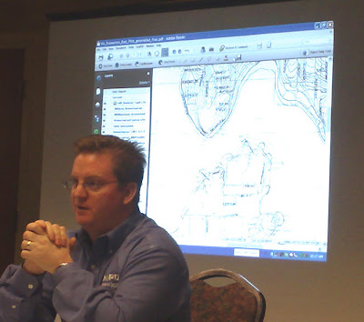
I got the latest on GeoPDF today at the Denver stop of the GeoPDF roadshow from TerraGo Technologies - more on that later. One of the cool things we heard about in a wrap-up was the next version of USGS quads that will be converted to GeoPDFs over the next 5 years. Granted, these daya are currently available as free GeoPDFs from the USGS, however, this next version (the next generation) will add loads more functionality and usefulness to these data. Look for GeoPDF quads to include 37 layers of information (yes, 37!) where the user can toggle on/off any of the layers of information (names, contours, transportation features, etc...) The quads will be searchable and users can query for required strings (like a place name, feature, road name) and these quads will also be color separated... perhaps coolest of all, these GeoPDFs will be easily ingested into ArcGIS! Stay tuned on this! See below for an image showing the next-gen USGS GeoPDF quadsheet as displayed by Jaymes Pardue of TerraGo Technologies. For more information on working with USGS Quadsheet GeoPDFs see this article Locate and Download free USGS GeoPDF maps using the Map Downloader - see also http://store.usgs.gov/locator and http://www.terragotech.com/support

Predictive Traffic Now Available Via a Location-Based Services Platform from deCarta
This out of the deCarta Devcon taking place this week in San Jose... INRIX Predictive Flow (Predictive Traffic data)for deCarta's geospatial software platform. INRIX predictive traffic services can now be easily integrated via the deCarta Traffic Manager extension to its Drill Down Server geospatial platform. This will allow deCarta customers to add real-time traffic and incident information, and for the first time, predictive traffic services to their location-based solutions. The solution promises to make available reduced drive times and pre-planning via optimal route selection. See www.decarta.com/developers and www.inrix.com
Validate that mobile web content via WC3 mobileOK
NEw today from the WC3 ... W3C provides new means for people to create and find mobile friendly content. W3C invites Web authors to run the alpha release of the W3C mobileOK checker and make their content work on a broad range of mobile devices. The W3C mobileOK checker runs the tests defined in the W3C mobileOK Basic Tests 1.0 Candidate Recommendation. Note - this service is in Alpha mode - see http://www.w3.org
National Geographic Topos
National Geographic is promoting a sale on NGS Topos... recall these data (sold by the State) enable users to quickly import topos, DEMs, hillshades, into your ArcGIS project where you can then create output to share with others via ArcGIS Explorer or KML and into Google Earth. Topo! data come in unprojected so users can then display them in a projection of choice. See more at www.topopro.com


November 12, 2007
GoSee4me - sell your photos to the highest bidder
OK, I'm on the fence with this one... I can't decide if its totally cool, or just plain odd! GoSee4me is building a network of amateur photographers (you can join) and members are sent on assignment based on their preferences. When you sign up you can say that you'll travel up to 100 miles to capture a photo based on a bid request. Those needing photos (I'm not sure why but I'm sure there's some good reasons.. like maybe PR people) send a bid request and the members bid on the job... "OK, I'll grab you a photo at the hockey game for $20 etc...) A pretty cool idea (I think) . I created an account but something I don't see is an area where members can promote their photos... let's say I'm downtown and happen to see Paris Hilton or some other famous person... wouldn't it be cool to be able to auction off that photo? Now that would be useful!!! I have a nice photo of Jack Dangermond taken last week in Denver... anyone interested ?? ;0) Ggo join the army or amateur photo buffs at www.GoSee4Me.com
Google Releases first look at Android SDK - Lures Developers with $10 million in Android Challenge
Yes indeed, Google today has released programming tools for the Android mobile-phone alliance for download, giving developers the ability to start writing software for phones due to start shipping in 2008. Some details...
In the Android Developer Challenge I, the 50 most promising entries received by March 3 will each receive a $25,000 award to fund further development. Those selected will then be eligible for even greater recognition via ten $275,000 awards and ten $100,000 awards.
Build Your Favorite Mobile Application
We welcome all types of applications but are looking to reward innovative, useful apps that make use of Android's capabilities to deliver a better mobile experience. Here are some suggested areas of focus to get you started:
- Social networking
- Media consumption, management, editing, or sharing, e.g., photos
- Productivity and collaboration such as email, IM, calendar, etc.
- Gaming
- News and information
- Rethinking of traditional user interfaces
- Use of mash-up functionality
- Use of location-based services
- Humanitarian benefits
- Applications in service of global economic development
- Whatever you're excited about!
Google will accept submissions from January 2 through March 3, 2008
Relevant Links:
Get the SDK at http://code.google.com/android/
Follow the Android Blog: http://android-developers.blogspot.com/
Developer's Challenge: http://code.google.com/android/adc.html
Get started with Android - http://code.google.com/android/intro/index.html

Image from the Android Emulator
AT&T hits Costco.. not a bad option if you need an iPhone or a new smartphone
I'm not on AT&T, although I wish I was sometimes. AT&T is the other major GSM carrier in the US - next to T-Mobile who I use. One huge advantage you'll find on AT&T is support for a much faster network which supports data-heavy services (like mobile TV, videos, and others). I've found over the years that many cool apps are not supported on T-Mobile by developers... generally due to some obstacles that they face including limited network speed. Another reason now to consider AT&T is that you can sign up at Costco... this is likely the best kept secret around but getting your next phone or adding a line at Coscto is a fantastic deal. You still need to sign up for a contact BUT, you can usually get a free phone, pay NO upfront fees, and best of all get your activation fee returned via rebate.. essentially you add a line for $0 - something you can't do anywhere else. I did this recently and had a great experience in adding lines for the kids.. best of all the rep was quite knowledgeable! FYI, you can register for mobile access on T-Mobile and Sprint at Costco as well. The kiosks are stocked with today’s leading handsets, including the Samsung A437 and A517, in addition to Nokia and Motorola models
Reminder - TerraGo Technologies GeoPDF road show
A reminder that the TerraGo roadshow is hitting 3 cities tomorrow including stops in Houston, D.C., and Denver. Join TerraGo Technologies for a two hour workshop to learn how to:
- Get complex geospatial data into the field in an application almost everyone already has and knows how to use
- Focus GIS professionals on more analysis and less administration
- Make field users self-sufficient with geospatial data
- Share geospatial data with anyone who has Adobe Reader installed on their computer
Stops include:
Washington DC 11/13/2007
Denver 11/13/2007
Houston 11/13/2007
Las Vegas 11/15/2007
Austin 11/15/2007
Chicago 11/15/2007
Kansas City 11/27/2007
St. Louis 11/29/2007
Phoenix 11/30/2007
Tucson 11/30/2007
Albany 12/04/2007
Register here and see also http://www.terragotech.com
Geography Awareness Week and GISDay 2007 some favorites
This week we are pleased to celebrate Geographic Awareness. In 1987, U.S. President Ronald Reagan signed legislation establishing the third week in November as Geography Awareness Week (GAW). Every year since then, the National Geographic Society has promoted the importance of geography to the public and to schools throughout the United States and in Canada during Geography Awareness Week. See our favorite GIS and geography edu resources in this Geography awareness week feature... did I miss your favorite??
read more | digg story
read more | digg story
FME 2008 to Offer Read and Write Support for SQL Server Spatial
This out of Safe Software this morning as FME 2008 beta now supports the new spatial data capabilities made available in the new SQL Server 2008 November Community Technology Preview (CTP). What this means is Microsoft users can now use FME to read and write SQL Server-based spatial data, as well as over 200 other CAD, GIS, raster and database formats. They can also use it to integrate non-spatial and spatial data for loading into SQL Server 2008. In the FME 2008 beta, SQL Server users will be able to see firsthand how they can use FME’s powerful data translation, transformation and integration capabilities to read and write spatial data to SQL Server 2008.
read more | digg story
read more | digg story
November 11, 2007
Autodesk on Mentor Software and open source
In a decent read, Computerworld mag recently interview Autodesk's Liam Speden to get a better handle on the company's plans for open sourcing the map projection & coordinate conversion technology recently acquired from Mentor Software. From the interview... "By enabling the open source community to develop and provide these enhancements, customers will benefit from more rapid innovation." Sharing a common set of coordinate systems and transformations appears to be the goal. No more need to re-engineer conversion technology... See Computerworld
community mapping = racial profiling?
Interesting to see how the latest community mapping efforts in LA has set off such a heated debate. It's interesting to contrast this with the developments that take place at such events as the recent ESRI Homeland security summit where it was recently discussed that cataloging and mapping a city's assets (public and private) is a mammoth task but one that is required in order to develop an effective emergency response plan and to secure situational awareness. Community mapping (mapping at the community level) typically involves gathering socio-economic variables in order to visualize their relationships (in time and space). But, when you throw "religion" into the mix watch out. It's somewhat confusing to think that the public has such a vocal outcry regarding such an effort yet people are demanding a secure place to live. Personally I can't understand why mapping the relationships and distribution of populations based on ethnicity is so controversial. Think of an effort to locate or monitor visitors to the country... it's well documented that migrants tend to try and assimilate themselves into a population that is similar in race, ethnicity, income and yes, even religion so unless one is aware of the cultural make-up of of a community how then is it possible to create that mental map? No doubt this outcry will persist but until we are able to add cultural layers to the database how is it possible to create the all important situational awareness and mental model of reality - map the infrastructure but don't map the people! More on the debate can be found in this LA Times article


Subscribe to:
Posts (Atom)