
October 04, 2008
A Search helper at AllTop - aggregation without aggravation
I have to give a shout-out to AllTop, particularly since this blog (AnyGeo) is now listed within the Mobile category (http://mobile.alltop.com/)... nice! Alltop is a relatively new (early 08) news/blog search aggregation resource that follows hot topics on the web. About Alltop... "You can think of an Alltop site as a “digital magazine rack” of the Internet. To be clear, Alltop sites are starting points—they are not destinations per se. The bottom line is that we are trying to enhance your online reading by both displaying stories from the sites that you’re already visiting and helping you discover sites that you didn’t know existed." See more at alltop.com or see this PR
October 03, 2008
DeviceAtlas 2.0 mobile device database
Looking for design specs on pretty much any mobile device? Look no further than the latest iteration of the Device database. Information on DeviceAtlas 2.0 - including the free Web-based version and free, fully licensed version for developers - is available at http://deviceatlas.com/


Managing Your Twitter via Tweetstats
Do you twitter? Better still, are you aware of your twittering stats? With tweeting becoming very commonplace, even for corporations (see @navteq, @esri, @cnn etc...) there's loads of cool third party apps to extend the functionality of this cool social networking resource. Tweet stats is a nifty utility that does exactly what the name says, provides details of your twitter stats. Simply enter your user-name and receive details of your usage like how often you tweet by day, hour, or even which platforms you use to tweet. Very cool stuff! See www.tweetstats.com
FYI, you can connect to me via twitter by locating user @gletham


FYI, you can connect to me via twitter by locating user @gletham


ah, to blog or not on the Biz card!
A small poll... is your blog (personal or corporate) on your business card or going to be listed on your next business card?
October 02, 2008
Music Almighty HEadset design from Nokia
An interesting and fun competition from Nokia where users are invited to submit an original design for a new headset! http://www.nokiamaheadsetdesign.com... enjoy!


Nokia all you can eat music and the S60 Touch UI is here
Nokia today has rolled out some cool new functionality today in a press meet. The big news includes Comes with music, an all you can eat music download serivice - buy it and keep it! currently available only in the UK. The company has also rolled out the S60 5 form factor featuring the long anticipated touch UI and the first device sporting the touch UI - teh Express Music 5800 - see video below. Interesting that the service will also be available to Nokia N95 8GB users.
With S60 5th Edition, the user interface is extended by the introduction of touch and with full support for tactile feedback. Enhanced display resolution support and a new Widescreen mode further compliments the touch UI and enables engaging visual experiences.
Also, for the first time, the platform includes a framework for the use of advanced sensor technology. This all allows S60 device manufacturers to create innovative new device concepts for a wider range of user segments, while preserving the rich capabilities of the existing software platform. The first S60 5th Edition based device, designed for music lovers, was announced today - the Nokia 5800 XpressMusic.
HomeZilla for the Canadian Homebuyers - local content done right!
Another awesome mashup catering to the real estate industry... Homezilla (homezilla.ca) - Neighourhood information for Canadian home buyers - HomeZilla has just released what they call "a one-stop shop for neighourhood information for Canadian home buyers". The service offers lists of schools, the distance to restaurants, parks and much more. It can be accessed for free and with just a single click. According to the developers, HomeZilla's mission is to make buying a home easier and faster. HomeZilla does this by quickly connecting you with valuable home-buying and neighbourhood information so you can make informed home buying decision. The webmap offers a pleasant UI that is fast and simple to use providing valuable information including information and POIs on schools, shops, parks, transit routes, restaurants, pubs, and even Canadadian census data. 2 Thumbs up on this clever mashup!
Some of the unique pieces of information available at HomeZilla includes:
See also the developer's blog here


Plain and simple, HomeZilla is simple and good at what it's supposed to do! Awesome maps, a simple UI, fast, and useful information... I love it!
Some of the unique pieces of information available at HomeZilla includes:
- 99% of all public Canadian schools
- Over 1000 fire stations across Canada
- Demographics like average age, median income, etc
- Rail transit in Vancouver, Edmonton, Calgary, Toronto, and Montreal
- Over 800 liquor stores from across Canada
See also the developer's blog here


Plain and simple, HomeZilla is simple and good at what it's supposed to do! Awesome maps, a simple UI, fast, and useful information... I love it!
October 01, 2008
which Smartphone would you like - Poll Results show Nokia N95
I recently posed a question to our readers... I asked, Which Mobile Device / Smartphone Do You Want Next?
If you could upgrade your mobile device next month which way would you go?? From roughly 100 responses the results are in:

If you could upgrade your mobile device next month which way would you go?? From roughly 100 responses the results are in:
- iphone 8.8%
- Bold 7.7%
- G1 20%
- N95 33.3 %
- dont need 5.5%
- Other 3.3%
- S60 other 20%

mapping through wine country - don't forget the GPS!
An interesting mobile application via WineTrailsGPS... Wine Trails GPS is dedicated to providing comprehensive Wine Country POI databases that may be uploaded into popular GPS units.
About the app... Wine Trails GPS is dedicated to providing comprehensive Wine Country POI databases that may be uploaded into popular GPS units. Wine and food lovers just upload these database files straight into their compatible units, and hit the road!
Wine Trails GPS is currently compatible with GARMIN GPS units. File conversions for TomTom and other devices will be offered in the future. Ideally, I'd rather see such an application mobilized for a smartphone, Symbian S60 device or even iPhone... they could be missing the boat on this one! See www.winetrailsgps.com or more in this announcement
Oh Where oh Where has the NIMA VMAP 1 data gone?
I gotta be honest with you... something that drives me up the wall is when public agencies either move or remove a web service, data product or ?? without any explanation or without any paper trail what so ever. Case in point, I have a popular data tip article on GISuser describing and pointing users to the NIMA VMAP data - theses data are... er, were easily accessible via ftp download from the NGA/NIMA website. Now it turns out that all the pointers to these data are broken and users simply get the familiar error page - try hitting this link and you'll see what I mean http://geoengine.nga.mil/ftpdir/archive/vpf_data/v1053.tar.gz.
If you head off to the VMAP 1 boundaries website, then select an area of interest (click on a yellow box), you are then sent to the raster roam page where you are provided with additional information on these data. Then the problem when you click on the FTP download link to access the .tar.gz file. Links are still live, however, the file with 0 for a file size is no longer available.
On the bright side, VMAP 0 data are available for download and you can also grab the data HERE as SHP files. Again, please don't waste your $$ buying the raw data from an online data "eating" resource like the datadepot or others... the same or even more currrent data are easily available via public sites like this.
Anyone have any ideas about this?? An email sent to the contact person provided has no yielded any response.
See http://geoengine.nga.mil/

September 30, 2008
GeoCommons Maker! discover geospatial data and make your own maps
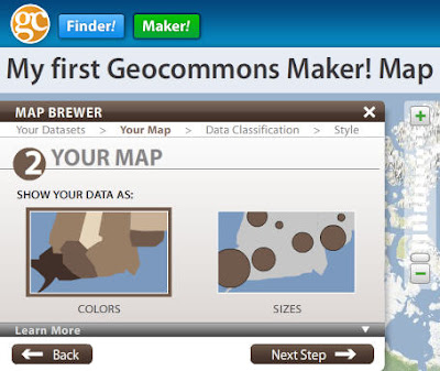
I've been messing around a bit with GeoCommons Maker! - coming to the public this week - sorry but you'll need to wait to try it for yourself - thanks Sean! You may already be familiar with the cool, GeoCommons Finder! web service (http://finder.geocommons.com/) enabling users to discover a wealth of geospatial data being shared with the community. Well now, this week the developers will be rolling out even more functionality to the GeoCommons portfolio in a service called Maker! Using GeoCommons Maker!, users can create a user account, search and discover data, save their maps, and share them. Obviously, the key component of Maker! is the "create" component. Once logged in, creating your own map is a snap. Search the vast data holdings and preview data, then create a custom my by adding your own clever title, add data, them your data in a number of ways, select a base map of choice from a number of open data providers. You can read more about Maker! in this piece that I just cranked out... I'm sure you'll enjoy Maker! once it's live...
 For more on Maker! See also http://www.geocommons.com/
 For more on Maker! See also http://www.geocommons.com/
September 29, 2008
Paul Newman, Newman's Own and his generosity to The GIS Institute and Service at Sea
Like drew Stephens, Director,The GIS Institute, Service at Sea I was also saddened this past week-end to hear about the passing of Paul Newman. What I wasn't aware of was how Newman reached so many people through his generosity, including the GIS Community. In a touching letter, Stephens described how in 2006, Newman's funding for The GIS Institute provided the seed capital to run our first proof-of-concept trip "Service for Africa", a six week project that delivered GIS training for over 100 people from 20 different conservation organizations in five African countries. This from Stephen's letter:
So how do the donations and legacy of Paul Newman affect the GIS community? In 2006, his funding for The GIS Institute provided the seed capital to run our first proof-of-concept trip "Service for Africa", a six week project that delivered GIS training for over 100 people from 20 different conservation organizations in five African countries. Alumnus of those courses have gone on to create a successful GIS Conservation community in Kenya, others have gone on to GIS related jobs in parks in Southern Africa, and still others are using GIS to care for the Gorillas in Uganda, the Cheetah of Botswana, and the creatures and mangroves of the Niger Delta.
Without the support of Newman's Own, the University students in Panama, and the community leaders working for healthy forests and Tepehaun Indian land rights in Mexico, would not be using GIS in their efforts to create a just and ecologically rich world. In the United States, funds went toward supporting Sealife Conservation, who work to eliminate marine debris from the oceans and estuaries of California, The Alaska Marine Conservation Council, who advocate for native fishing and hunting rights, and The Prince William Sound Science Center, supporting science and education efforts in that unique setting. These organizations all received GIS software grants from ESRI, and GIS training services from The GIS Institute, supported by Newman's Own donations.

Image Credit: Newsmansown.com
Thanks for sharing the letter Drew... well done! And thanks to Newman's Own donations into this amazing industry. See http://www.serviceatsea.org/
Team Garmin Edition of Edge 705 GPS-Enabled Cycling Computer
Now here's a nifty device for you cyclists... a Team Garmin model! Some specs and details: The Edge 705 represents several breakthroughs in cycling technology, including power compatibility, wireless unit-to-unit connectivity and the ability to monitor GPS position, heart rate, speed, cadence, altitude and gradient on the same display. The orange and blue Team Garmin edition of the Edge 705, which was first seen on Team Garmin’s handlebars at the 2008 Tour de France, comes bundled with a heart-rate monitor, speed and cadence sensor and City Navigator mapping, which provides turn-by-turn directions and millions of preloaded points of interest. And Team Garmin athletes and recreational cyclists alike can share data – including official race courses, saved rides, waypoints and workouts –through ANT+™ wireless technology. NICE! See more


Geotagging with Microsoft Pro Photo Tools
Microsoft Pro Photo Tools provides a set of tools for photographers to perform various tasks with their images—including RAW captures. The current version enables you to quickly geotag your photos, view and edit metadata, and more.

Subscribe to:
Posts (Atom)