 Flickr has finally made geotagging simple as drag and drop on a map... sweet! All one needs to do is go into the user "organize" utility and select the "map" tab (new). A map will be presented (Yahoo! map obviously) and then you simply select your photo(s) of choice, zoom in to a location on the map, drag and drop a picture onto the map, and that's it... sweet! Some added privacy protection has been provided so you can set geotagging to be made available to your friends or everyone. Then, when visitors browse photos, if a photo is geotagged an optional map tag will be hyperlinked to a map where the photo can be seen on a map. You'll know if a photo is geotagged if it says something to the effect of "taken in San Diego, CA" and has a "map" hyperlinked. See sample photo here. More on the flickr geotagging functionality available in the Flickr Blog or see this handy video tutorial (source of inspiration for this post was scrappad.. thanks!)
August 28, 2006
Flickr Geotagging - finally embeded in the organize tool and its a breeze!
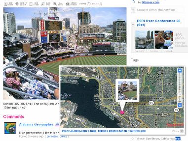
Flickr has finally made geotagging simple as drag and drop on a map... sweet! All one needs to do is go into the user "organize" utility and select the "map" tab (new). A map will be presented (Yahoo! map obviously) and then you simply select your photo(s) of choice, zoom in to a location on the map, drag and drop a picture onto the map, and that's it... sweet! Some added privacy protection has been provided so you can set geotagging to be made available to your friends or everyone. Then, when visitors browse photos, if a photo is geotagged an optional map tag will be hyperlinked to a map where the photo can be seen on a map. You'll know if a photo is geotagged if it says something to the effect of "taken in San Diego, CA" and has a "map" hyperlinked. See sample photo here. More on the flickr geotagging functionality available in the Flickr Blog or see this handy video tutorial (source of inspiration for this post was scrappad.. thanks!)
Subscribe to:
Post Comments (Atom)
1 comment:
The flickr maps had been enormously successful, by the way - 1.4 million photos have been geotagged in two days. That more than they expected in a month.
Post a Comment