Showing posts with label British Columbia. Show all posts

July 21, 2008

Province of BC unlocks digital data and strikes a deal with Google

For some time we've know that the Province of BC and Google have been striking backroom deals on sharing data... Last week, Agriculture and Lands Minister Stan Hagen announced GeoBC, (http://www.geobc.gov.bc.ca/) will provide 24/7 access to the province's geographic database in partnership with Google. This information will be available online at geobc.gov.bc.ca and from Google Earth. Apparently, this move makes B.C. the first government in Canada to supply Google with access to its information. Interesting to see that the Provicne has noted on the GeoBC/Google gateway page that data layers for use within ArcExplorer are coming soon.

According to Mark Zacharias, acting assistant deputy minister for GeoBC (nice position Mark... he was a master's student at U Vic when I was doing my degree in geography/GIS there),
by making this available on Google Earth, "not only will you be able to zoom in on an area and get a high-resolution view, you'll also be able to download about 600 different themes from the provincial geo data warehouse." The Government hopes that this information will drive innovation and new business opportunities in B.C. I'd like to know, can you view and download BC TRIM data files using this method though? TRIM files are 1:20K topo files (digital) that are akin to a USGS topo DRG file - it's been some time, however, in the past contractors had to pay big $$ to get digital TRIM data - a public GIS data product. Source: Vancouver Sun

For data see - GeoBC Web Map Services (KMZ) This package contains a variety of layers such as Agricultural Land Reserves, Contours, Lakes, Rivers, Roads, Railways, Imagery, Lot Lines, Map Grids, and Parks and Protected Areas. Selected BC Park Profiles (KMZ), This package contains links for selected BC Parks to the web page containing information about that park. Note, you can also copy/paste these links into Google Maps for preview.

July 01, 2008

Happy Canada Day

Just realized (courtesy of a txt from Dad) that today is Canada day... have a great one you Canucks! I'll see if I can locate a Kokanee or similar later today, otherwise I'll have to settle for a Molson CDN... cheers!

November 26, 2006

Winter in British Columbia, poor traffic reports and more

Well, its the end of November and winter is on us here on the West coast of British Columbia. Its amazing that we actually have snow this early in the year (typically we get one or 2 snow falls here on Vancouver Island) as we rarely get any white stuff before the new year. Making it worse for yours truly is the fact that I'm in the middle of moving! We packed up the house yesterday and then tried to make our way south to Victoria (I'm about 100 km north in Nanaimo) but had to turn back due to bad weather. People often joke that we dont know how to drive, however, things are pretty messy here, add to that people aren't that well prepared (ie. many use all season tires rather than studded snow tires etc...). What really makes it rough here is that we get huge air masses that have tons of moisture (aka. the Pineapple express) and when it collides with cold air from the north you get a real nasty situation with frozen slush, black ice etc... Last night I was driving with the family (wife, 3 kids, the dog) and we ran into a road closure on the main highway over a stretch known infamously here as the Malahat.. plain and simple.. its one of the scariest roads you'll encounter... trust me on this one. The government here has ignored doing anything about it as apparently its too costly to create a better route. I guess the 700,000 people on the Island aren't important enough (but PEI on the East coast is important enough to get a freaking brigde.. dont get me going on that one!!) and we can spend $billions preparing the highway to Whistler for the Olympics. So the road was closed and I detour to the only alternative, a pathetic part of our wonderful ferry system that connects Mill Bay with Brentwood Bay. The ferry runs in and out of an un-manned terminal (ie. no information provided to stranded travelers) and the final sailing to the rest of the World is at about 6:20 PM. Saturday night with the highway shut down the ferry system added one extra sailing... did i mention that the piece of crap "ferry" holds 16 vehicles! So, as I sat there with the family with about 45 cars ahead of me i turned around and came home. Finally safe and sound at home and Paige, te sick one can get some commfort. As I surf the Internet seeking information and road conditions, my confidence in the BC communication resources is lacking as every hour passes. The Min of transportation provides the requisite cameras and some textual information, however, I notice that some cameras dont appear to update when they say they are (I notice the same vehicle in a camera for about 20 minutes) and a textual report displayed gives me information and weather from about 4 hours ago... nice! Once again I have to wonder why cant we have a resource available to the public for their safety that can commpare to what we find south in Washington, Oregon etc... I've been researching weather for my coming trip to Fort Collins next week and have great confidence in traffic conditions and weather reports provided by the DOTs of Washington, Oregon, Idaho, Utah, and Colorado... kudos to all these resources! Anyone from BC MOTH out there listening... how about some resources to keep Joe public safe? HEre's what I want... detailed maps with reports that show changing conditions at mile intervals (even 10 mile intervals would be nice). How about more than 2 web cameras between the trecherous 100 km stretch between Nanaimo and Victoria? Simple, color coded maps (ie. yellow, green, red) to show hazards, with a legend that makes sense and links to detailed textual reports... all of this information is out there, lets unlock it from some of the IT departments that are hoarding it! Later from the great White west. On the upside, since the cupboards are bare here (recall we packed yesterday) we've come up with some interesting meals andf made some great drinks using up the contents of the liquor cabinet... hurricance mix, peach snapps, tequilla (or rum)...mmmmmmm

September 21, 2006

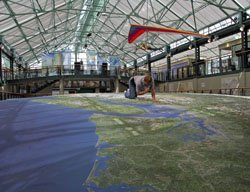
BC Experience bankruptcy means the end of the line (likely) for World's largest 3D map

Recall the BC Experience... you know, the massive 3D map of British Columbia on display in Victoria BC, Canada at the heart of a new tourist attraction - Victoria is a big tourist destination (a scaled-down version was on display in San Deigo at the ESRI conference map gallery). Well, unfortunately, poor planning and some bad luck on the part of the company that launched the tourist attraction has resulted in some financial woes. Looks like bankruptcy is a likely scenario in the near future as the venue is in debt to the tune of some $8.5 million owed to more than 228 creditors. The anchor attraction at the venue was the World's largest solid terrain model - a 40-foot by 74-foot, three-dimensional, full-color model of British Columbia. The British Columbia model is larger than a "doubles" tennis court and is the world's largest physical-terrain model ever created from digital data sources. The 3D model was created by California-based STM - complete details on how the model was built can be found here - http://www.gisuser.com/content/view/9216/