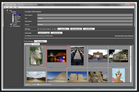
Microsoft Pro Photo Tools provides a set of tools for photographers to perform various tasks with their images—including RAW captures. The current version enables you to quickly geotag your photos, view and edit metadata, and more.

Showing posts with label geocode. Show all posts
Showing posts with label geocode. Show all posts
September 29, 2008


May 02, 2008
GeoTagging with Shozu explained
Are you a mobile camera power user? If so then you know about Shozu (I hope) if not then you should, particularly if you like to blog your photos, flickr them or share them with others. Shozu recently updated to R4 and the geotagging support has been enhanced - to date I was never really happy with the results. Over on the Shozu Blog the team has provided a nice primer on how the shozu GeoTagging works and provides a cool tour of San Fran - see also shozu.com
September 07, 2007
Wiki + photos + GPS = Cool! - Share your GPS tagged photos with GlobalMotion
GlobalMotion has just launched a new Wiki focused on real world places: www.globalmotion.com. GlobalMotion has focused on making the content creation process easy and fun, using the millions of geotagged photos out there on the web in a useful & fun way. This could be a very cool way to use and share your geotagged Nokia N95 GPS tagged photos. The app has a very cool UI that meshes a Google Maps position, overview map, your photo, and related information... all in a friendly wiki style
Some details on the app... GlobalMotion was started by Joost Schreve. Joost is an avid travel enthusiast. Joost hitchhiked on a sail boat from The Philippines to Hong Kong and then climbed with his skis above 8,000 meters in the Himalayas. He has always been into technology so he is marrying his two passions with his websites he started. A few other advisors to the company include: Hap Klopp, founder of North Face outdoor clothing and gear, as well as Per Enge who is a Professor of Aeronautics and Astronautics at Stanford University.
Some details on the app... GlobalMotion was started by Joost Schreve. Joost is an avid travel enthusiast. Joost hitchhiked on a sail boat from The Philippines to Hong Kong and then climbed with his skis above 8,000 meters in the Himalayas. He has always been into technology so he is marrying his two passions with his websites he started. A few other advisors to the company include: Hap Klopp, founder of North Face outdoor clothing and gear, as well as Per Enge who is a Professor of Aeronautics and Astronautics at Stanford University.
August 20, 2007
Geotagging / Geolocating your flickr photos with Yahoo! zonetag and locr - a short tutorial
ok... more on the geotagging photos sent to flickr via shozu and my Nokia N95 GPS-enabled smartphone. I've recently been doing some research to figure out exactly how to geotag my photos, and get them up on flickr then view on a map. From the outside looking it one would think, "no problemmo", however, things are not often as simple as they would seem. Luckily there's a couple of good third party apps that work very well. Those of you that depend on out of the box functionality that wil accomplish this will have to try again!
My research has led me to believe the following:
- there's much confusion out there about this.
- it's a total pain in the arse to accomplish using the Nokia N95 out of the box
- it's not as simple as blogs and other write ups lead you to believe
- many people seem to be having trouble with many different aspects of this.
- some people seem to be experiencing difficulties uploading via shozu from the Nokia N95 - I have yet to see any issues with this.
- apparently you can tag photos from N95 directly with GPS coords if you run sprt tracker or load the maps application - I've yet to be able to accomplish this seemingly simple task.
Enter Yahoo! Research labs zonetag and locr. Zonetag from Yahoo! has just recently come out with a version that supports Symbian S60 3rd edition devices (Nokia N80, N95, 6110 etc...). The application is very simple to use and it works. Simply install zonetag, setup your preferences (I'm still tweaking these) load the app, connect the GPS to grab your fix, take a photo, upload to flickr... it's as simple as that! Once on flickr your photos will have a hyperlink to map the photo and the coordinates will display when you view the photo on a map. So far I've had excellent results with this application.
Locr (www.locr.com) operates in a similar manner. Install the app, setup an account, connect to GPS to get a fix, snap a photo, upload to flickr and to locr if you wish. Your photos are maintained in a locr account and from the mobile device you can also view your photos or photos that are near you. Once feature I'm not big on is that the application takes over the camera and you don't seem to get the full functionality from your device. This contrasts with Zonetag where you use the camera in the same mode that you normally would with your device.
Please note, you should have an all you can eat data plan to use these applications otherwise the results (and your next phone bill) could be scary! I use shozu for uploads normall, however, it seems that when using zonetag or locr you are actually bypassing the shozu functionality... I'm not worried as I can use al teh data I want. Stay tuned for more on these apps. Overall, I give locr a 3.5 out of 5, zonetag gets 4.5 out of 5!
Related weblinks:


My research has led me to believe the following:
- there's much confusion out there about this.
- it's a total pain in the arse to accomplish using the Nokia N95 out of the box
- it's not as simple as blogs and other write ups lead you to believe
- many people seem to be having trouble with many different aspects of this.
- some people seem to be experiencing difficulties uploading via shozu from the Nokia N95 - I have yet to see any issues with this.
- apparently you can tag photos from N95 directly with GPS coords if you run sprt tracker or load the maps application - I've yet to be able to accomplish this seemingly simple task.
Enter Yahoo! Research labs zonetag and locr. Zonetag from Yahoo! has just recently come out with a version that supports Symbian S60 3rd edition devices (Nokia N80, N95, 6110 etc...). The application is very simple to use and it works. Simply install zonetag, setup your preferences (I'm still tweaking these) load the app, connect the GPS to grab your fix, take a photo, upload to flickr... it's as simple as that! Once on flickr your photos will have a hyperlink to map the photo and the coordinates will display when you view the photo on a map. So far I've had excellent results with this application.
Locr (www.locr.com) operates in a similar manner. Install the app, setup an account, connect to GPS to get a fix, snap a photo, upload to flickr and to locr if you wish. Your photos are maintained in a locr account and from the mobile device you can also view your photos or photos that are near you. Once feature I'm not big on is that the application takes over the camera and you don't seem to get the full functionality from your device. This contrasts with Zonetag where you use the camera in the same mode that you normally would with your device.
Please note, you should have an all you can eat data plan to use these applications otherwise the results (and your next phone bill) could be scary! I use shozu for uploads normall, however, it seems that when using zonetag or locr you are actually bypassing the shozu functionality... I'm not worried as I can use al teh data I want. Stay tuned for more on these apps. Overall, I give locr a 3.5 out of 5, zonetag gets 4.5 out of 5!
Related weblinks:

Flickr account holders can easily sign up for a zonetag key and start using it

Photos uploaded to flickr using zonetag - the title is automatically loaded with your location - notice the "map" link

The photo appears exactly where I took it on the map!

Zonetag GPS connect function on N95 (left) and locr application as seen on the device (right)

Zonetag GPS connect function on N95 (left) and locr application as seen on the device (right)
March 20, 2007
iBegin - Yellow Page data for the masses.. or perhaps for the mashups!
An interesting launch today in Toronto from iBegin... iBegin Source - a comprehensive source of nationwide business data - combined with a self-updating system! iBegin Source relies on both traditional sources, such as telco records, federal/state agencies, and new methods such as web-crawling technology that captures business data from across the Internet. In a first for the industry, iBegin Source introduces a trackback system that allows users to automatically update entries, as well as a wiki-like interface that enables anyone to update the data. The previous one way relationship between data provider and customer has now been changed into a two way street. And for the mashup developers... iBegin Source will also make geocoded data available for its paying customers - allowing easy integration with a mapping application such as Google Maps. Taking this one step further, iBegin Source also provides the nearest major intersection, making it easier for end-users to find any business. See ibegin.com
Subscribe to:
Posts (Atom)