Interesting to see how Yahoo! is looking to Google for help in serving up ads for their search results. this comes as Yahoo! tries to fend off hostile takeover from Microsoft. Could Google possible own any more of the online ad space?? see more on CNN
Microsoft had this to say in a recent PR... "Any definitive agreement between Yahoo! and Google would consolidate over 90% of the search advertising market in Google's hands. This would make the market far less competitive, in sharp contrast to our own proposal to acquire Yahoo! We will assess closely all of our options. Our proposal remains the only alternative put forward that offers Yahoo! shareholders full and fair value for their shares, gives every shareholder a vote on the future of the company, and enhances choice for content creators, advertisers, and consumers."

Showing posts with label yahoo. Show all posts
Showing posts with label yahoo. Show all posts


March 23, 2008
WikiNear, the location-sensitive WiKiNear - using Yahoo's fire eagle + Google maps API
WikiNear, the location-sensitive WiKi... this cool app. uses Yahoo's fire eagle - you'll need an invitation from Yahoo! to use this - the skinny of it is that the app. uses your location to locate Wiki pages that are closest to your current location and displays them on a Google map (not sure if this is tied to your Yahoo! account setup or ?) I'm still dabbling with it and plan to run off now to test it on my mobile as the documentation says that the app. is optimized for use on a mobile - I would assume that it will hopefully determine my location from the mobile and grab WiKi content based on that location. See more at Simon Wilson's blog or jump to http://wikinear.com/ - see also http://fireeagle.yahoo.net/ - note, Fire Eagle is in Beta and thus, only a limited number of users are given access so you may have to wait a bit to try this one. See also Mashable for more http://mashable.com/2008/03/22/wikinear/
December 19, 2007
Yahoo! maps adds drag and drop routes and compare routing
New from Yahoo! maps... drag and drop your routes, compare old and new routing options. Don't like the route that Yahoo! maps suggests... no problem, now you can simply drag and drop to create an updated path, perhaps avoiding road closures, congestion or ?? This from the Yahoo! local blog... Now following your favorite freeway on Yahoo! Maps is as easy as drag & drop. Once you get your directions to your destination, if you don’t quite like what you see, you can pick up your route and drop it somewhere else, and we’ll drive you through the area you select in the most efficient manner. If that’s still not quite right, you can tug on the route again until it’s perfect.

I really like the compare the routes dialog box that shows up after you alter your route. Shows distance in old route compared to new option


I really like the compare the routes dialog box that shows up after you alter your route. Shows distance in old route compared to new option

September 23, 2007
Schmap boast Schmap for Mac, online guides, an open developer platform, and customizable widgets using Google, Yahoo! or Microsoft maps
Schmap, the developer and publisher of those very cool, free guides and Schmapplets has not only just passed the 30 million download mark, but they also have some cool updates. Most recently, the company is boasting Schmap for Mac, online guides, an open developer platform, and customizable widgets.
Schmap for Mac - Schmap desktop guides are now Mac compatible: Schmap Guides for both Mac and Windows can be downloaded for free at www.schmap.com.
Schmap Guides online - Readers who don’t require all our desktop functionality can now browse Schmap Guides online, complete with the same content as their desktop counterparts. Schmap Washington DC, for instance, can be browsed online at www.schmap.com/washingtondc.
User authored “schmapplets” - open platform for users to author their own map-integrated travel or local content. A showcase selection of user authored schmapplets can be viewed at www.schmapplets.com.
Customizable map widgets - simple for anyone to customize a map widget for a website or blog, with choice of size, color, city and map or satellite image via Google, Yahoo or Microsoft. Schmap map widgets can be customized at www.schmap.com/widgets.
More about Schmap Guides:
Online and desktop travel guides available at www.schmap.com.
30 million desktop travel guides downloaded since March 2006.
Guides include photos from 50,000 travelers and local residents.
200 worldwide destinations schmapped.
Unique platform integrates maps and travel guide content.
See more about Schmap and schmapplets in the article at http://www.gisuser.com/content/view/12070/
Tha sample widget below uses the Yahoo! maps API
Schmap for Mac - Schmap desktop guides are now Mac compatible: Schmap Guides for both Mac and Windows can be downloaded for free at www.schmap.com.
Schmap Guides online - Readers who don’t require all our desktop functionality can now browse Schmap Guides online, complete with the same content as their desktop counterparts. Schmap Washington DC, for instance, can be browsed online at www.schmap.com/washingtondc.
User authored “schmapplets” - open platform for users to author their own map-integrated travel or local content. A showcase selection of user authored schmapplets can be viewed at www.schmapplets.com.
Customizable map widgets - simple for anyone to customize a map widget for a website or blog, with choice of size, color, city and map or satellite image via Google, Yahoo or Microsoft. Schmap map widgets can be customized at www.schmap.com/widgets.
More about Schmap Guides:
Online and desktop travel guides available at www.schmap.com.
30 million desktop travel guides downloaded since March 2006.
Guides include photos from 50,000 travelers and local residents.
200 worldwide destinations schmapped.
Unique platform integrates maps and travel guide content.
See more about Schmap and schmapplets in the article at http://www.gisuser.com/content/view/12070/
Tha sample widget below uses the Yahoo! maps API
September 13, 2007
my first Yahoo! mapmixer - fort collins + Census Bureau Tiger data
I had to test the Mapmixer for myself now that I located some cool data from the US CEnsus bureau. Using data from http://tiger.census.gov I created a simple map that uses 1998 TIGER/Line® data and 1990 Decennial Census data. I mixed it using the mapmixer app and voila.. ok this is cool! Try messing with the layer opacity tool to see the 2 different map layers that I combined. Sweet! Try for yourself at http://maps.yahoo.com/mapmixer
Yahoo! goes mixing maps with mapmixer
This is a cool app and very premlim but this Mapmixer project out of yahoo! research labs is quite cool. I'm not sure of the usefulness yet but I guess its cool! See http://mapmixer.com & http://maps.yahoo.com/mapmixer Apparently this is an internal pet project that lets users create a mashup by adding any GIF or JPG map to a Yahoo! map session as an overlay. Users can also embed the map as an iframe into their webpage (see below) . Any idea where to find some georeferenced GIFs? Thanks to slashgeo for this tip!
I want a printer friendly map from Google, Yahoo! Live Local Ask Maps!
I'm just printing out some driving directions from Google Maps and Ask maps and it has me wondering.. whay can't we get a really nice, effective printer friendly output from any of these mapping services? The maps and directions are great, however, every time I print one of these maps the map background is always some very light or pale yellow or tan color and basically serves only one purpose... it uses up my valuable printer cartridges! Hey map service... I don't need a background color on maps that I print out! It looks great and is effective online but its totally useless to include on the output. Wouldn't a couple of print options be nice.. a basic for quick output to take with you on your drive (ie. no background shading etc..., and an enhanced option with all the colors, shading etc.. so you could hang it on your wall!) my 2 cents! On a side note.. I noticed a banner ad from Ask Maps running on DIGG today. The banner promotes drag and drop mapping and directions... where is the drag and drop and what is this referring to???

FYI, I used several services to see if I got different estimates on a planned trip. Here's what I found (note: all routed me the same way)
Ask Maps http://maps.ask.com/
9 miles Time: 15 minutes
Google Maps http://www.google.com/maps/
10.1 mi – about 16 mins up to 20 mins in traffic
Yahoo! http://maps.yahoo.com
9.2 miles Time : 16 mins (approx)
I like the way Yahoo returned the business name, phone number when I entered the address of a business
Live search - http://maps.live.com/
9.7 miles Time: 12 minutes


FYI, I used several services to see if I got different estimates on a planned trip. Here's what I found (note: all routed me the same way)
Ask Maps http://maps.ask.com/
9 miles Time: 15 minutes
Google Maps http://www.google.com/maps/
10.1 mi – about 16 mins up to 20 mins in traffic
Yahoo! http://maps.yahoo.com
9.2 miles Time : 16 mins (approx)
I like the way Yahoo returned the business name, phone number when I entered the address of a business
Live search - http://maps.live.com/
9.7 miles Time: 12 minutes

August 28, 2007
YAhoo! Pipes news map - a great mashup
An interesting find in this clever Yahoo! Pipe that mashes up news (topic of your choice) with a Yahoo! map. Try it out - search on a term like "esri" then scroll through the results on this map interface. The app grabs news from google news (yes indeed, GISuser.com news gets crawled by this news crawler - a great benefit of getting your news listed here) and displays on the map where you can then scroll through the results, view a synopsis and click-through for a full read if the caption looks interesting. To top it off you can get the results as JSON or KML... sweet! See the News Map Pipe HERE


August 20, 2007
Geotagging / Geolocating your flickr photos with Yahoo! zonetag and locr - a short tutorial
ok... more on the geotagging photos sent to flickr via shozu and my Nokia N95 GPS-enabled smartphone. I've recently been doing some research to figure out exactly how to geotag my photos, and get them up on flickr then view on a map. From the outside looking it one would think, "no problemmo", however, things are not often as simple as they would seem. Luckily there's a couple of good third party apps that work very well. Those of you that depend on out of the box functionality that wil accomplish this will have to try again!
My research has led me to believe the following:
- there's much confusion out there about this.
- it's a total pain in the arse to accomplish using the Nokia N95 out of the box
- it's not as simple as blogs and other write ups lead you to believe
- many people seem to be having trouble with many different aspects of this.
- some people seem to be experiencing difficulties uploading via shozu from the Nokia N95 - I have yet to see any issues with this.
- apparently you can tag photos from N95 directly with GPS coords if you run sprt tracker or load the maps application - I've yet to be able to accomplish this seemingly simple task.
Enter Yahoo! Research labs zonetag and locr. Zonetag from Yahoo! has just recently come out with a version that supports Symbian S60 3rd edition devices (Nokia N80, N95, 6110 etc...). The application is very simple to use and it works. Simply install zonetag, setup your preferences (I'm still tweaking these) load the app, connect the GPS to grab your fix, take a photo, upload to flickr... it's as simple as that! Once on flickr your photos will have a hyperlink to map the photo and the coordinates will display when you view the photo on a map. So far I've had excellent results with this application.
Locr (www.locr.com) operates in a similar manner. Install the app, setup an account, connect to GPS to get a fix, snap a photo, upload to flickr and to locr if you wish. Your photos are maintained in a locr account and from the mobile device you can also view your photos or photos that are near you. Once feature I'm not big on is that the application takes over the camera and you don't seem to get the full functionality from your device. This contrasts with Zonetag where you use the camera in the same mode that you normally would with your device.
Please note, you should have an all you can eat data plan to use these applications otherwise the results (and your next phone bill) could be scary! I use shozu for uploads normall, however, it seems that when using zonetag or locr you are actually bypassing the shozu functionality... I'm not worried as I can use al teh data I want. Stay tuned for more on these apps. Overall, I give locr a 3.5 out of 5, zonetag gets 4.5 out of 5!
Related weblinks:


My research has led me to believe the following:
- there's much confusion out there about this.
- it's a total pain in the arse to accomplish using the Nokia N95 out of the box
- it's not as simple as blogs and other write ups lead you to believe
- many people seem to be having trouble with many different aspects of this.
- some people seem to be experiencing difficulties uploading via shozu from the Nokia N95 - I have yet to see any issues with this.
- apparently you can tag photos from N95 directly with GPS coords if you run sprt tracker or load the maps application - I've yet to be able to accomplish this seemingly simple task.
Enter Yahoo! Research labs zonetag and locr. Zonetag from Yahoo! has just recently come out with a version that supports Symbian S60 3rd edition devices (Nokia N80, N95, 6110 etc...). The application is very simple to use and it works. Simply install zonetag, setup your preferences (I'm still tweaking these) load the app, connect the GPS to grab your fix, take a photo, upload to flickr... it's as simple as that! Once on flickr your photos will have a hyperlink to map the photo and the coordinates will display when you view the photo on a map. So far I've had excellent results with this application.
Locr (www.locr.com) operates in a similar manner. Install the app, setup an account, connect to GPS to get a fix, snap a photo, upload to flickr and to locr if you wish. Your photos are maintained in a locr account and from the mobile device you can also view your photos or photos that are near you. Once feature I'm not big on is that the application takes over the camera and you don't seem to get the full functionality from your device. This contrasts with Zonetag where you use the camera in the same mode that you normally would with your device.
Please note, you should have an all you can eat data plan to use these applications otherwise the results (and your next phone bill) could be scary! I use shozu for uploads normall, however, it seems that when using zonetag or locr you are actually bypassing the shozu functionality... I'm not worried as I can use al teh data I want. Stay tuned for more on these apps. Overall, I give locr a 3.5 out of 5, zonetag gets 4.5 out of 5!
Related weblinks:

Flickr account holders can easily sign up for a zonetag key and start using it

Photos uploaded to flickr using zonetag - the title is automatically loaded with your location - notice the "map" link

The photo appears exactly where I took it on the map!

Zonetag GPS connect function on N95 (left) and locr application as seen on the device (right)

Zonetag GPS connect function on N95 (left) and locr application as seen on the device (right)
May 29, 2007
Yahoo! Maps making Google Trends yet
I just noticed that Google's Zeitgeist was recently updated with Google Trends - intgeresting to see that Yahoo maps hits the list but google maps doesn't. See for yourself on http://www.google.com/trends/
May 21, 2007
Oreilly Radar on mapping portals - look at Google maps, Yahoo!, ask
Over at Oreilly Radar Brady Forest has taken a quick take at online mapping portals - Yahoo!, Ask, Google, etc... Forest did a good job examining trends in local search, exploring the immersive data products (think 2.5 D) and looking at the routing and data suppliers used by the big boys. Some interesting companies reference by Forest include http://www.facet-tech.com/, http://www.facet-tech.com/SightMap/SightMap.htm, and http://urbanmapping.com - see the article at http://radar.oreilly.com/archives/2007/05/trends_of_onlin.html
March 17, 2007
Info Week looks at Maps, Mashups, APIs and Web 2.0
An interesting read about Google mashups from Information week... nice to see this topic getting such prominent placement in the mainstream media. The article discussed the proliferation of mashups (more than 35,000 so far), the latest offering from Yahoo! (Pipes), and a look at some other APIs available, like that from ForiusOne - See Maps Meet Mashups at http://www.informationweek.com/story/showArticle.jhtml?articleID=198001255 - related to this article - see FortiusOne http://www.fortiusone.com/ and Yahoo! Pipes http://pipes.yahoo.com/pipes/
October 14, 2006
Testing geocoder US and the Yahoo! Maps Web Services - AJAX API
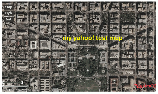
Killing a bit of time here while watching a little NCAA football this morning, I ran into some info from the Yahoo Local weblog. I decided to request an application ID and test out how long it would take for me to create a simple little map using ylocal. The App Id request took me about 5 seconds once I signed into my yahoo account (don't have one yet??? where have you been!) I then grab a little bit of sample code provided by a tutorial describing how to get started with the Yahoo! AJAX API - see here. In no time I simply substitute my ID for the generic one listed in the sample and voila. I can now easily resize and re-center my map and the updates are reflected on my web page. All I need now is to geocode an address and reposition my map... this is easily done using the app provided at http://geocoder.us/. Let's see now if I can place the map here within the blog... hopefully blogger will accept the code... oops.. looks like I can't embed the map within the blog post, however, I do have an html page that I could easily add to a website. I have to wonder if Google doesn't allow Yahoo! maps to be embedded within their apps.. ie. like this blogger weblog!Given that it took me about one minute to create I could easily start messing around and customizing the map if i was to dig deeper into the sample code and tutorials. See http://ylocalblog.com and try for yourself. Register your API app and get a code
Subscribe to:
Posts (Atom)