 Ok, this is off topic but its so totally awesome I have to boast about it to those of you who aren't aware of it. HNL games are now available for FREE viewing via google Video. You can't watch them live but after a delay of 48 hours you can sign in and sit back to watch a game that you may have missed. Imagine, sitting around an airport you can access the service using your WiFi enabled laptop (hey, i can even use my new WiFi enabled Nokia N80 smartphone) and watch a game.. this is sweet! Many of you Southerners may not relate but those of us north of 49 are drooling after this one! Simply jump to http://video.google.com/nhl.html, select your favorite team, and pipck a game. you can them watch the full game in about 1:5 hours (no commercials!) So now I can catch all the Canuck games when I move to Colorado... nice!

November 03, 2006
off topic - Google video delivers HNL games
Ok, this is off topic but its so totally awesome I have to boast about it to those of you who aren't aware of it. HNL games are now available for FREE viewing via google Video. You can't watch them live but after a delay of 48 hours you can sign in and sit back to watch a game that you may have missed. Imagine, sitting around an airport you can access the service using your WiFi enabled laptop (hey, i can even use my new WiFi enabled Nokia N80 smartphone) and watch a game.. this is sweet! Many of you Southerners may not relate but those of us north of 49 are drooling after this one! Simply jump to http://video.google.com/nhl.html, select your favorite team, and pipck a game. you can them watch the full game in about 1:5 hours (no commercials!) So now I can catch all the Canuck games when I move to Colorado... nice!
Location, Location, Location: Does It Matter in Field Service?
Market research... Almost two-thirds of service organizations recently surveyed by the Aberdeen Group stated that they currently use location-based services (LBS) such as GPS, GIS, and AVL to support their field service operations. The research findinngs fromm a survey of 250 companies shows that LBS has resulted inn increased revenues.. plain and simple! this comes from The Aberdeen Group - see http://www.aberdeen.com/
National Association of Realtors urging consumers to buy now... gee, there's a surprise!
From the off-topic section... a PR item today caught my eye and reminded my why I can't stand the entire real estate industry. you know, the self-policing establishment that can scare the consumer into reacting just the way they want you to! Get this one... National Association of Realtors(R) is launching a national campaign to urge home buyers who have been waiting tobuy the home of their dreams to act now before the market changes. So in short... adding more panick to the current hype surrounding the changing real estate market, their campaign is focused on "informing" the consumer that they better buy now... or else! Realtors advising people they better buy... gee, there's a headline for you. Makes about as much sense as the realtors that are constantly wanting their clients to drop their prices for a quick sale... of course they want a quick sale but do they care about YOU taking a $10k or $20k hit? Information about NAR is available at http://www.realtor.org
Iran's Lut Desert World's hottest place
Need to get away from the winter blues? Maybe you should consider heading off for a mountain climbind excursion to the World's hottest location. Where is the world's hottest place? Weather reports are too sparse to tell. But all-seeing infrared heat sensors on satellites can do the trick. A study published last week gives the 2003 honor to Queensland, Australia, with that year's high of 156.7 degrees F. (69.3 degrees C). Iran's Lut Desert claimed the title in 2004 and 2005 with highs of 154.4 and 159.3 degrees F., respectively (that's 68 and 70.7 degrees C). Source - http://www.csmonitor.com/2006/1102/p16s01-sten.htm
November 02, 2006
ILMF 2007 registration now a go
Online conference registration for ILMF 2007 is now available at the International LIDAR Mapping Forum (ILMF) web site, www.lidarmap.org. The early registration rate of $375 is available until December 1, 2006; Late registration after December 1 is $490. Registration provides access to all conference sessions and materials; complete conference proceedings; access to all sponsored social events, meals, breaks and reception. Save the date - Baltimore, Maryland - February 12-13
Free data tip - USGS DEMs (SDTS) for the western states
A nice score here for those in need of USGS DEMs for the western states.... DIGITAL ELEVATION MODELS OF THE WESTERN STATES . Simply click through the map UI, select an area of interest, then download the DEM
CALIFORNIA 7.5 minute DEMs by map (native format)
CALIFORNIA 7.5 minute DEMs by name (sdts format)
ARIZONA 7.5 minute DEMs by name (sdts format)
COLORADO 7.5 minute DEMs by name (sdts format)
IDAHO 7.5 minute DEMs by name (sdts format)
MONTANA 7.5 minute DEMs by name (sdts format)
NEVADA 7.5 minute DEMs by name (sdts format)
NEW MEXICO 7.5 minute DEMs by name (sdts format)
OREGON 7.5 minute DEMs by name (sdts format)
UTAH 7.5 minute DEMs by name (sdts format)
WASHINGTON 7.5 minute DEMs by name (sdts format)
WYOMING 7.5 minute DEMs by name (sdts format)
Bookmark page - http://geogdata.csun.edu/page3/page3.html
Attractive wall map of Africa from California Geological Survey
The crew at the California Geological Survey has announced the preliminary release of its fifth wall map - a very attractive map of Africa. The map is approximately 42" x 47" in size and is based upon a Universal Transverse Mercator projection. The shaded relief terrain is based upon SRTM dems and the surface details come from MODIS satellite imagery. A. sample map in jpg format has been included for general scrutiny and can be seen at http://130.166.124.2/wall_maps/Africa_3.jpg - nice work!
Pete's webcast from Autodesk (reminder) CAD & Geospatial Data - Classified
A reminder about a webcast of interest taking place this morning from autodesk. You'll see how object classification allows you to easily organize objects in your map by the real-world features they represent.
CAD & Geospatial Data - Classified
Date: Thursday, November 9, 2006
Time: 11:00 - 12:00 a.m. (PDT) - register online at http://usa.autodesk.com/adsk/servlet/oc/offer/form?id=8185407&siteID=123112&aid=31207&program_id=49503&ch=EM
Date: Thursday, November 9, 2006
Time: 11:00 - 12:00 a.m. (PDT) - register online at http://usa.autodesk.com/adsk/servlet/oc/offer/form?id=8185407&siteID=123112&aid=31207&program_id=49503&ch=EM
November 01, 2006
Kerski and Baker the latest to hook up with ESRI EDU program
Congrats go out to Joseph Kerski (long time colleague and Geo-acquaintance of mine) and to Tom Baker on their new positions at ESRI - officially announced today by ESRI. Kerski comes from the USGS and Baker from the University of Kansas where both have been heaviliy involved in promoting and developing GIS educational material, GIS EDU outreach, GIS lesson plans, etc... Baker will lead the creation of a new ESRI EDU portal and Kerski will oversee ESRI GIS classroom content. For realted weblilnks see www.esri.com/university and www.esri.com/k-12
Add yourself to the GISuser Mapkit - a fun social networking API from platial
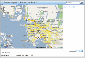 Platial, the very cool social networking mashup community has a public API available to anyone who wants to test their service and embed their own map into their website or blog. I created a "GISuser" Mapkit over at GU - a test mapkit that I created in seconds. Please feel free to test the app and add yourself to this map... enjoy! See the GISuser MapKit here see also platial.com for more on the API. Platial and their mashup apps have actually been around for some time. I recall seeing their very cool stuff at Where 2.0 earlier this year and they were definitely one of the coolest and most talked about apps that were showed off... social networking was definitely BIG at where 2.0
October 31, 2006
2006 State and Metropolitan Area Data Book
A reminder about a very useful, new resource from the Census Bureau... The State and Metropolitan Area Data Book features more than 1,500 data items for the United States and individual states, counties and metropolitan areas from a variety of sources. The files include data published for 2005 population and housing unit estimates and many items from the 1990 and 2000 Census of Population and Housing. Information in the State and Metropolitan Area Data Book covers the following topical areas: age, agriculture, births, business establishments, communications, construction, cost of living, crime, deaths, education, elections, employment, energy, finance, government, health, households, housing, immigration, income, manufactures, marriages and divorces, media, natural resources, population, poverty, race and Hispanic origin, residence, retail sales, science and engineering, social services, tourism, transportation, and veterans. See the complete publication here - http://www.census.gov/prod/2006pubs/smadb/smadb-06.pdf (PDF) or http://www.census.gov/compendia/smadb/
USGS Seamless Data Server.. a simple reminder
In a recent reminder from sommeone at the USGS, I have to admit that I have neglected to promote this fabulous data resource. Most users know about it (or should know about it), therefore, as a result it sometimes gets forgotten. Thing of the seamless data distribution system as the grand-daddy of the USGS geospatial repositories... and then some! This site has complete coverage of theNational Elevation Dataset that supercedes Digital Elevation Models, complete DOQQcoverage, over 30 Tb of urban imagery, one-time coverage of full resolution Landsatimagery, and much more. Also, the data are seamless, so you can put a box aroundthe data without having to figure out quadrangles and then having to assemble themall. Here's some details from our friends at the USGS if you need to hear more... Free downloads are availble - up to 1.6 Gbytes of data in 100 MB files in one user request. Users have unlimited access to the interactive map and can make unlimited requests.The amount of coverage area depends on the number of products selected for download.For example, if NED 1 Arc Second is selected as the only product a user can downloadup to a 30 square degree area. But, if NED 1 arc second and NED 1/3 arc second areselected, then the area available for download will be considerably smaller. To seethe various sizes of coverage area for each product, click on the List of Productsdrop down, select the desired product. User can define an area of interest by drawing a box, defining coordinates, or useavailable templates to cut out the area. The first method of drawing a box (square or rectangle) is best for defining ageneral area. The coordinates are displayed, in decimal degrees, in the bottom leftcorner of the window as the mouse is moved over the map. The second method ofdefining coordinates can be used when the user wants a precise area and knows thecorner coordinates. The third method is the use of provided templates, such as 7.5min quadrangles. Bookmark this one, or maybe even set it as your homme-page! http://seamless.usgs.gov/
Food for thought... Resist assholeholics and the The No Asshole Rule
Speaking of Guy Kawasaki (see post from earlier today), Guy's most recent words of wisdom touch on the topic of being an asshole! This made in reference to a Book Review of The No Asshole Rule by Robert Sutton. In familiar fashion, Guy has me in stitches describing the book and providing a list of what kinds of things make you an asshole! Guy admits to have being one and to have been in contact with a few as well.. I have to admit, I guess I've been one and have definitely known a few as well! For some fun Guy makes a suggestion on how you can come up with your very own Google Asshole ranking where you can guage in relative terms your asshole ranking (my words) - maybe the term "asshole-ocity" would be fitting? Good news... according to the test I'm only a fraction of the asshole that Guy is ;0) Finally, check out Guys tips on how to avoid being an asshole... words of wisdom. I like this one - Resist assholeholics from the start! See http://blog.guykawasaki.com/2006/10/you_have_to_lov.html
Rules of conduct for the GIS professional
As a GISP you are expected to conduct yourself and your business according to some codes of ethicsc as set up by the "Institute". Just today the GIS Certification Instatute has layed out their Code of Ethics and rules for the conduct of GIS professionals. Among them; We shall acknowledge our errors and shall not distort or alter the facts, All data shall have appropriate metadata documentation sufficient to meet the minimum standard as stated here, When notified of an error in the database, the professional will take action to correct it... if you're in need of some guidelines on how to conduct yourself see details here http://www.gisci.org/rules_of_conduct.htm or see the PR announcement here. If anything, these are some fine business rules that any company would want to strive to adhere to... compliance will no doubt enamour you to your clients!
A smart way to wrap up a GIS user mobile!
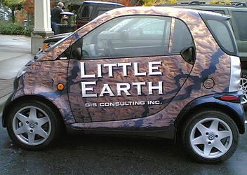 This one is for the "recently spotted" category. As I pulled in to a parking for lunch at a local sushi restaurant the other day I notice a cool little "smart" car in the stall next to me. The car is "wrapped up" in a 3D terrain map design and has a sign on it promoting a local GIS consulting firm. I have to be honest, I never heard of the firm but the paint job on the car was way cool... I've often said I want to paint up the Expedition as the GISuser Mobile - when I get to Fort Collins you may infact see this! - but for now, this was a great source of inspiration. Do you have a GIS themed company car? If so blast me a photo... you may wind up on the blog like this guy! Photos is from the Little Earth GIS Consulting Inc, Nanaimo, BC - photos is also posted on my GISuser flickr stream
A good read - GIS for the urban environment, ESRI Press
 I haven't had time yet to do a full-blown review, however, I have skimmed briefly a new title from ESRI Press and its pretty darned awesome! Anyone involved in urban geography, local government and GIS should grab a copy of this, read it, and keep it near your desk! The book starts of with the basics of GIS (even answers what is a map?) and then delves into spatial modeling, data classifcation, data visualization, data sources, and anything that a local government GIS user needs to know. Of particualr interes and setting this book apart from anything else I've seen is the focus on GIS Projects, including the project lifecycle, planning, and project management... nice! The book finishes up with a lengthy discussion on GIS ethics and offers up some excellent case studies. See GIS for the Urban Environment
Amanda Congdon and AmandaAcrossAmerica chats with Guy Kawasaki
 Amanda Congdon, video blogger, actress, and much more has recently added a video interview with one of my favorite evangelists, Guy Kawasaki. I know, where's the geo in this? No worries, its not strictly a geo thing, however, its down-right interesting and cool! AnyGeo reader Andy tipped me off about his post (thanks again Andy) and I had to rethink a bit what I could recall about Amanda. Sure, there's the eye-candy factor, however, she's also one of the most well known video casters on the web - she's also appeared on CSI so she must be pretty damned cool! Amandy hosts the video cast on her blog AmandaAcrossAmerica, which notably uses a Google mashup UI... nice touch (that's provided by Mapbuilder.net). If you have 10 minutes to kill today sit back and listen to Guy... he's a great motivator and holds a wealth of knowledge about many things including venture capital funding, the art of the start up, PR, marketing, business 2.0, the web, blogging, and hockey! I've met Guy and even got a signed copy of his latest book a while back (thanks again Guy)... enjoy the video cast and bookmark Amanda and Guy's blog! Gee, maybe one day I can get an interview with Amanda!!! I won't hold my breath though ;0) See http://amandacongdon.com/america/ & http://blog.guykawasaki.com/
October 30, 2006
GISuser Data Search Engine with 1900 new resources (mostly for Free data)
Recall last week I made mention of the Google Co-op API and the new functionality that enables users (like me) to create their very own search engine. Since that time I've added some 1900+ of my favorite GIS resources (mostly data resources) which has resulted in a customized search tool that yields some awesome results if I say so myself! Many of the links come submitted directly to me for inclussion in vary sections at GISuser.com (ie. link section, free data resources, state clearinghouses etc...) Check it out and be sure to drop me a line if you don't think your favorite data resource is listed yet See the GIS Data search Engine HERE
Location-Based social networking
Social networking is all the rage... its all about connecting with others. Think second life, youtube, flickr, SMS.ac, yadayada... how about networking based on location? That's exactly what NavXS is all about... from the developer I get this... the smartphone / PocketPC application is used in combination with GPRS/UMTS/WLAN networks. Its an online navigation tool which use MapTile from MapProvider like google.maps, Microsoft, yahoo or ask.com. Additional features are: see your friends were they are in real-time, send them messages without SMS ;) The service is in beta but is boasted to work very well. See http://navxs.com - supports Windows Mobile 5 and Java based devices. Note, they also have a blog to support them as well at http://navxs.blogspot.com
Thales rebrands as Magellan
A good marketing move in my mind... kudos to the crew at Thales for rebranding their Mobile mapping family as Magellan and going forward with promotions under the new but familiar umbrella of Magellan.. nice stuff! No doubt many people in the past had trouble pronouncing the old company's name THALES (no, not pronounced th-ale-s) but rather was correctly pronounced Tal-is. I believe I've read in the past that one of the biggest no-no's in marketing is selecting a company name or brand that nobody can pronounce or spell... I like Magellan... sounds geospatial too! See http://pro.magellangps.com/en/solutions/mobilemap/ - they have some very spanky mobile mapping products!
October 29, 2006
searching with Ms Dewey holding your hand
Have you checked out the latest in search from Microsoft's live.com search engine... enter Ms. Dewey (MSDewy). An interesting way to search the web hosted by a virtual hostess (Janina Gavankar) who walks you through your searches with a slight attempt at humor! While you wait she thinks, muses, and pesters you to try and keep you interested while the search engine grinds away. For now I'll stick with my google search but for some fun everyone needs to atleast check it out for a laugh (or not). See http://www.msdewey.com/
Subscribe to:
Posts (Atom)